
Embark on an epic journey and Bike Across America along the legendary TransAmerica Bicycle Trail. Spanning over 4,200 miles from the Pacific coast in Astoria, Oregon, to the Atlantic shores of Yorktown, Virginia, this iconic route offers an unparalleled adventure for cyclists seeking to explore the diverse landscapes and rich history of the United States. This comprehensive guide delves into the history of the trail, highlights key sections, and provides essential information for planning your own unforgettable bike across America experience.
The Historic Roots of the TransAmerica Bicycle Trail
The TransAmerica Bicycle Trail’s inception dates back to 1973, born from the ambitious vision of Adventure Cycling Association’s co-founder during a ride from Alaska to Argentina. Conceived as a grand celebration for the nation’s bicentennial in 1976, the trail quickly moved from an idea to reality through a monumental mapping and guidebook creation effort. Dubbed “Bikecentennial,” the inaugural event saw an astounding 4,000 cyclists, mostly in their twenties and many new to long-distance cycling, take on the challenge of biking across America. Organized in groups with trained leaders, these pioneers, often on basic bikes and without modern cycling gear, set forth on a journey that would profoundly impact their lives.
The experience of cycling across America proved transformative. Many from that original 1976 group, and countless others who have since traversed the trail, echo the sentiment: “I learned more about this country in 90 days than most people learn in a lifetime.” This enduring impact underscores the unique perspective and deep connection to the land and its people that a bike across America journey provides.
The Classic Coast-to-Coast Cycling Route
The TransAmerica Trail is renowned as the quintessential route to bike across America. It weaves through iconic landscapes, including the majestic Yellowstone and Grand Teton National Parks, offering cyclists a front-row seat to some of the United States’ most breathtaking scenery. Beyond the natural beauty, the trail boasts a unique cultural element: many establishments along the route, from cozy cafes to welcoming accommodations, maintain journals filled with entries from cross-country cyclists over the years, creating a living history of the trail itself.
Planning for a bike across America trip on the TransAmerica Trail typically involves dedicating around three months. While some cyclists opt for a faster pace, allowing ample time enriches the experience, providing opportunities for sightseeing and immersion in the diverse regions traversed.
Section 1: Oregon Coast to Willamette Valley (Astoria, OR to Coburg, OR)
Your bike across America adventure commences in Astoria, Oregon, a city reminiscent of San Francisco with its hilly terrain. A rewarding climb to the Astoria Column offers panoramic views that are a fitting start to your journey. The initial days are characterized by stunning coastlines, charming state parks, dramatic ascents and descents, and the allure of fresh seafood. As you pedal inland, the route transitions into the fertile Willamette River Valley. Eugene stands as the largest city in this section, providing a significant resupply point.
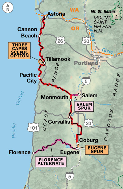 TransAmerica Bicycle Trail Section 1 Map: Astoria, OR to Coburg, OR
Section 2: Cascades to Eastern Oregon High Desert (Coburg, OR to Baker City, OR)
Leaving the lush greenery west of the Cascade Mountains, you’ll encounter a stark contrast as you enter the drier landscapes around McKenzie Pass. The road over McKenzie Pass is a highlight, cutting through an ancient lava field and revealing awe-inspiring vistas of the Three Sisters and other volcanic peaks. Central and eastern Oregon present a dry, mountainous environment, emphasizing the need to carry sufficient water. A must-visit is the National Historic Oregon Trail Interpretive Center near Baker City, which offers a powerful connection to the pioneering spirit of westward expansion.
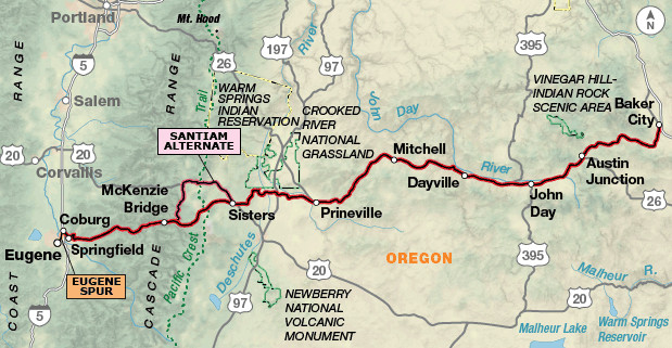 TransAmerica Bicycle Trail Section 2 Map: Coburg, OR to Baker City, OR
Section 3: Idaho River Rides and Montana Mountains (Baker City, OR to Missoula, MT)
Idaho welcomes you with a picturesque ride along the Little Salmon and Salmon rivers, interspersed with significant Native American historical sites. The route then follows the Middle Fork Clearwater and Lochsa rivers, a stunning stretch that includes the longest gradual ascent of the entire trip, stretching approximately 70 miles. Conquering Lolo Pass marks your entry into Montana and the eventual approach to Missoula. Missoula, a vibrant college town and home to Adventure Cycling Association headquarters, serves as a cyclist’s haven, offering a welcoming “cyclist’s lounge” and all necessary amenities.
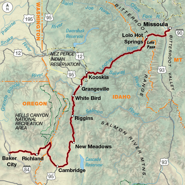 TransAmerica Bicycle Trail Section 3 Map: Baker City, OR to Missoula, MT
Section 4: Montana’s Big Sky Country to Yellowstone (Missoula, MT to West Yellowstone, MT)
Montana unfolds with breathtaking panoramas, expansive valleys, and challenging mountain passes. The approach to Yellowstone National Park is filled with anticipation for the unparalleled natural wonders ahead.
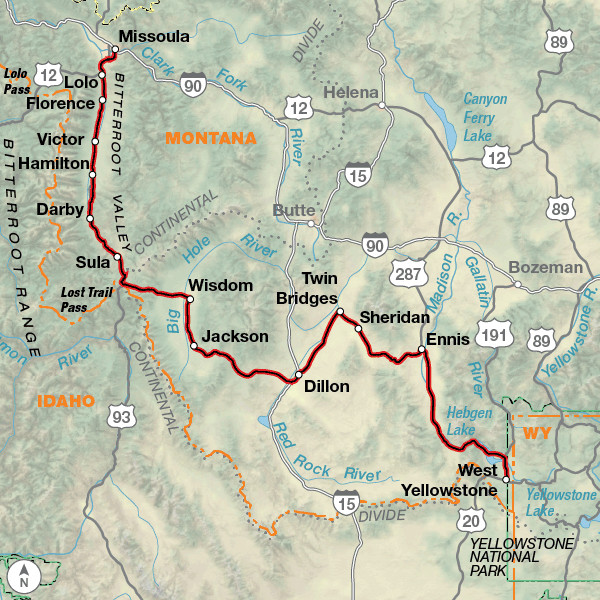 TransAmerica Bicycle Trail Section 4 Map: Missoula, MT to West Yellowstone, MT
Section 5: Yellowstone and Grand Teton National Parks, Wyoming’s Wild West (West Yellowstone, MT to Rawlins, WY)
Yellowstone and Grand Teton National Parks in Wyoming stand as iconic highlights of biking across America. Allocate extra days to fully immerse yourself in the geysers, wildlife, and majestic landscapes of Yellowstone and the towering peaks of the Tetons. Towns like Dubois and Lander retain a distinct Western character, reflected in their architecture and cuisine, adding to the authentic experience.
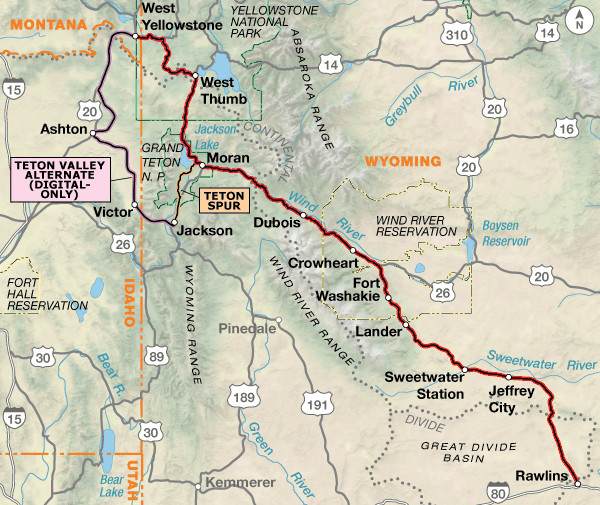 TransAmerica Bicycle Trail Section 5 Map: West Yellowstone, MT to Rawlins, WY
Section 6: Colorado Rockies and Continental Divide (Rawlins, WY to Pueblo, CO)
The scenery dramatically shifts from high desert to alpine as you reach Kremmling, Colorado. The resort towns of Frisco and Breckenridge in Summit County offer excellent opportunities for rest days. Prepare for a significant climb to cross the Continental Divide at Hoosier Pass, reaching an elevation of 11,542 feet amidst snow-capped peaks. As you descend from the Rockies, Royal Gorge Park provides a thrilling break, with options to walk across the Arkansas River bridge, take a helicopter tour, or raft through the gorge. Pueblo marks the halfway point of the TransAmerica Trail – a milestone to celebrate!
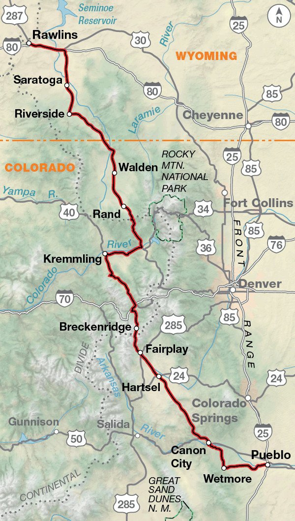 TransAmerica Bicycle Trail Section 6 Map: Rawlins, WY to Pueblo, CO
Section 7: Eastern Colorado Plains to Western Kansas (Pueblo, CO to Alexander, KS)
Eastward from Pueblo, the landscape transitions to the drier eastern plains of Colorado and western Kansas. Water becomes a critical resource in this region. Around Haswell, Colorado, the distant Rocky Mountains fade from view. City parks in Kansas often offer refreshing swimming pools, a welcome respite from the heat. Consider early morning and evening riding to avoid the midday sun.
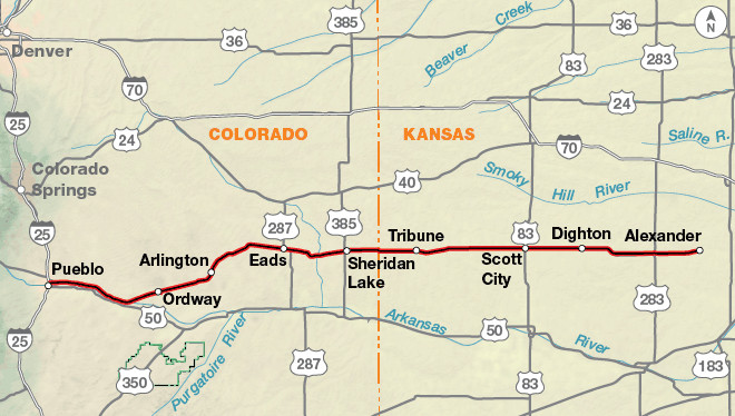 TransAmerica Bicycle Trail Section 7 Map: Pueblo, CO to Alexander, KS
Section 8: Flatlands of Kansas (Alexander, KS to Girard, KS)
Kansas presents a landscape of vast, flat plains. Enjoy the famed pies at Cooky’s in Golden City, Missouri, as you approach the eastern edge of the state.
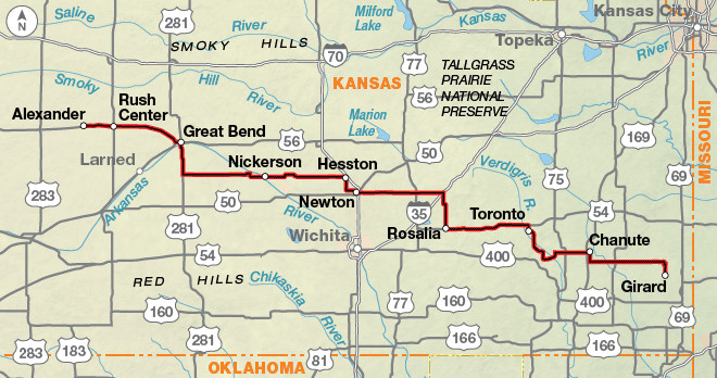 TransAmerica Bicycle Trail Section 8 Map: Alexander, KS to Girard, KS
Section 9: Missouri’s Ozark Highlands (Girard, KS to Murphysboro, IL)
The flat terrain of the Great Plains gives way to the rolling hills of Missouri. This section introduces Civil War history sites, excellent canoeing opportunities in Eminence, and the natural waterpark at Johnson’s Shut-Ins State Park.
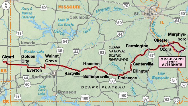 TransAmerica Bicycle Trail Section 9 Map: Girard, KS to Murphysboro, IL
Section 10: Kentucky’s Rolling Farms and Appalachian Foothills (Murphysboro, IL to Berea, KY)
Crossing the Mississippi River at Chester, Illinois, leads you to Carbondale, another vibrant college town. A ferry ride across the Ohio River brings you into Kentucky, where fireflies illuminate your campsites at night. Kentucky is characterized by rolling hills, white-fenced farms, and woodlands as you approach Berea, the gateway to the Appalachian Mountains. A detour south offers the chance to explore Mammoth Cave National Park, the world’s longest cave system.
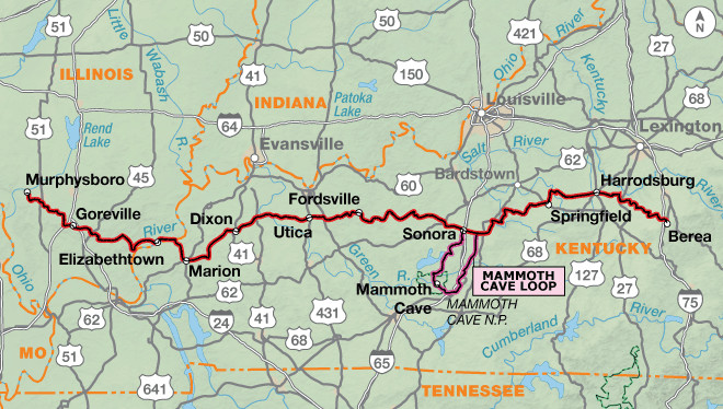 TransAmerica Bicycle Trail Section 10 Map: Murphysboro, IL to Berea, KY
Section 11: Appalachian Mountains (Berea, KY to Christiansburg, VA)
Past Berea, the trail ventures into the Appalachian Mountains, featuring challenging ascents and descents and a section along the scenic Blue Ridge Parkway in Virginia.
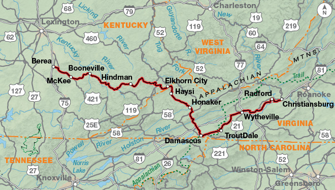 TransAmerica Bicycle Trail Section 11 Map: Berea, KY to Christiansburg, VA
Section 12: Virginia Plantations to Yorktown (Christiansburg, VA to Yorktown, VA)
The mountainous terrain softens into rolling hills and flatlands as you cycle through lush plantations and farmlands in Virginia. The final leg of your bike across America journey is steeped in American Revolution history, culminating at Colonial Williamsburg and Yorktown, situated on the Chesapeake Bay, the official end of the TransAmerica Bicycle Trail.
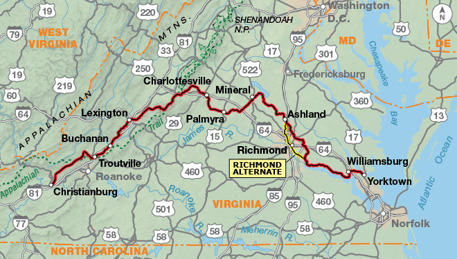 TransAmerica Bicycle Trail Section 12 Map: Christiansburg, VA to Yorktown, VA
Route Terrain and Elevation Profile
While some western sections of the TransAmerica Trail follow river valleys and are relatively flat, anticipate daily climbs between Oregon and Colorado. Mountain passes in the Rockies are generally long but not excessively steep, offering exhilarating descents. Kansas is predominantly flat. Missouri, through the Ozarks, and eastern Kentucky, through the Appalachians, present short, steep climbs, some potentially requiring walking. Surprisingly, Virginia features the highest total elevation gain of any state along the route.
| TransAmerica Trail – Main Route |
| Section | Distance | Elevation | Total Climb | Avg. Climb/mile |
|—|—|—|—|—|
| Total | 4204.9 miles | Minimum: 0 ft. Maximum: 11,535 ft. | 216,330 ft. east bound 216,495 ft. west bound | 51 ft. per mi. east bound 51 ft. per mi. west bound |
| 1 | 224.5 miles | Minimum: 0 ft. Maximum: 840 ft. | 9,955 ft. east bound 9,400 ft. west bound | 44 ft. per mi. east bound 42 ft. per mi. west bound |
| 2 | 341.0 miles | Minimum: 425 ft. Maximum: 5,330 ft. | 19,680 ft. east bound 16,780 ft. west bound | 58 ft. per mi. east bound 49 ft. per mi. west bound |
| 3 | 408.4 miles | Minimum: 1,225 ft. Maximum: 5,235 ft. | 23,615 ft. east bound 23,900 ft. west bound | 58 ft. per mi. east bound 59 ft. per mi. west bound |
| 4 | 329.8 miles | Minimum: 3,120 ft. Maximum: 7,420 ft. | 15,645 ft. east bound 12,355 ft. west bound | 47 ft. per mi. east bound 37 ft. per mi. west bound |
| 5 | 350.0 miles | Minimum: 5,325 ft. Maximum: 9,570 ft. | 19,065 ft. east bound 19,000 ft. west bound | 54 ft. per mi. east bound 54 ft. per mi. west bound |
| 6 | 389.5 miles | Minimum: 4,650 ft. Maximum: 11,535 ft. | 20,210 ft. east bound 22,310 ft. west bound | 52 ft. per mi. east bound 57 ft. per mi. west bound |
| 7 | 287.8 miles | Minimum: 2,080 ft. Maximum: 4,730 ft. | 2,310 ft. east bound 4,940 ft. west bound | 8 ft. per mi. east bound 17 ft. per mi. west bound |
| 8 | 326.1 miles | Minimum: 815 ft. Maximum: 2,085 ft. | 5,905 ft. east bound 7,015 ft. west bound | 18 ft. per mi. east bound 22 ft. per mi. west bound |
| 9 | 411.0 miles | Minimum: 360 ft. Maximum: 1,565 ft. | 24,945 ft. east bound 25,415 ft. west bound | 61 ft. per mi. east bound 62 ft. per mi. west bound |
| 10 | 400.4 miles | Minimum: 325 ft. Maximum: 1,030 ft. | 24,110 ft. east bound 23,510 ft. west bound | 60 ft. per mi. east bound 59 ft. per mi. west bound |
| 11 | 370.5 miles | Minimum: 655 ft. Maximum: 3,755 ft. | 31,850 ft. east bound 30,760 ft. west bound | 86 ft. per mi. east bound 83 ft. per mi. west bound |
| 12 | 365.9 miles | Minimum: 0 ft. Maximum: 3,335 ft. | 19,040 ft. east bound 21,110 ft. west bound | 52 ft. per mi. east bound 58 ft. per mi. west bound |
Planning Your Bike Across America Trip
The ideal window to bike across America on the TransAmerica Trail is from May through September. Be mindful of potential snow in the Rocky Mountains, especially at higher elevations like Hoosier Pass in Colorado, which exceeds 11,500 feet. While prevailing winds are westerly, local patterns are variable, so prepare for both tailwinds and headwinds regardless of direction. Allocate approximately three months for a comfortable crossing, allowing time for exploration and sightseeing.
Accommodation options range from private campgrounds and city parks to national and state parks and national forests. Kansas is known for its cyclist-friendly hospitality, with city parks commonly used for camping. Food, water, and lodging become more readily available from Missouri eastward to Virginia. Consider joining Warmshowers, a hospitality exchange network for cycle tourists, for additional lodging opportunities.
TransAmerica Trail Highlights
The TransAmerica Trail is punctuated by numerous points of interest, offering diverse experiences:
Section 1: Pacific Coast, Tillamook Cheese Factory, Chachalu Museum, Fort Yamhill State Heritage Area, Oregon Dunes National Recreation Area (Florence Alternate), McKenzie Pass.
Section 2: Smith Rock State Park, John Day Fossil Beds National Monument.
Section 3: National Historic Oregon Trail Interpretive Center, Nee-Me-Poo Trail, Nez Perce National Historic Park, Travelers’ Rest State Park.
Section 4: Bannack State Park, Big Hole Battlefield National Monument.
Section 5: Yellowstone National Park, Grand Teton National Park.
Section 6: Hot Sulphur Springs State Wildlife Area, Hoosier Pass, Royal Gorge Bridge and Park.
Section 7: “Skyscraper of the Plains”.
Section 8: Quivira National Wildlife Refuge, Kansas Cosmosphere and Space Center.
Section 9: Alley Spring & Mill (Ozark National Scenic Waterways).
Section 10: Johnson’s Shut-Ins State Park, Cave-In-Rock State Park, Mammoth Cave National Park (Mammoth Cave Loop), Lincoln Homestead State Park.
Section 11: Breaks Interstate Park, Mount Rogers National Recreation Area.
Section 12: Blue Ridge Parkway, Monticello (Home of President Thomas Jefferson), Ash Lawn (Home of President James Monroe), Richmond National Battlefield Park, Colonial National Historical Park, Williamsburg, Virginia.
Ready to Bike Across America?
The TransAmerica Bicycle Trail offers an unparalleled opportunity to experience the breadth and beauty of the United States on two wheels. With careful planning and preparation, your bike across America adventure will be a journey of discovery, challenge, and unforgettable memories. Start planning your transcontinental cycling tour today!