
Embark on an unparalleled cycling adventure with the Great American Rail-Trail, a developing route stretching over 3,700 miles from Washington, D.C., to Washington State. This ambitious project connects more than 150 existing rail-trails, greenways, and multi-use paths, offering a unique opportunity to traverse the United States by bike. With over 55% of the route already established, now is the perfect time to explore sections of this incredible trail and plan your journey.
Discovering the Great American Rail-Trail Route
The Great American Rail-Trail offers a preferred route designed to provide cyclists and other trail users with a high-quality, safe, and non-motorized travel experience. Carefully curated in partnership with state and local trail organizations, the route prioritizes existing trails and paths, ensuring a contiguous and reasonably direct path across the nation. For those seeking Bike Trail Directions, understanding the route’s structure is key to planning your trip.
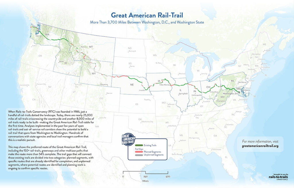 Great American Rail-Trail interactive map (2023) – Image courtesy RTC
Great American Rail-Trail map showcasing bike trail directions and route across the USA.
The interactive map is an invaluable tool for visualizing the bike trail directions and planning your adventure. It highlights the completed sections, states along the route, and connecting trails. For detailed bike trail directions, the map allows you to zoom into specific areas and explore the existing trail networks.
States Along the Bike Trail Directions
The Great American Rail-Trail passes through numerous states, each offering unique landscapes and trail experiences. Understanding which states the trail traverses is crucial for planning your bike trail directions and breaking down your journey into manageable sections.
From East to West, the Great American Rail-Trail currently routes through these states:
- Washington, D.C.
- Maryland
- Pennsylvania
- West Virginia
- Ohio
- Indiana
- Illinois
- Iowa
- Nebraska
- Wyoming
- Montana
- Idaho
- Washington State
While the majority of the route follows the preferred path, a Mountain West Detour exists between Chadron, Nebraska, and St. Regis, Montana. This detour, developed in partnership with Adventure Cycling Association, provides temporary bike trail directions to navigate a 960-mile gap in the developing trail.
Trails Composing the Bike Trail Directions
The Great American Rail-Trail is not a single, continuous trail but rather a route composed of over 150 individual trails. These trails are the building blocks of the cross-country route, and knowing some of them can be helpful when seeking bike trail directions for specific segments.
For example, in Wyoming, the route incorporates several established trails, offering diverse riding experiences:
- Douglas Trail System
- Al’s Way
- Casper Rail Trail
- Platte River Trail
- Greybull River Walk
- East Bighorn River Trail
- Beck Lake Park Bike Trail
Exploring the Trails on Route section provides links to TrailLink, where you can find detailed information, maps, and even user reviews for many of these component trails, further assisting in your bike trail directions planning.
Criteria for Bike Trail Directions: Ensuring a Quality Experience
The selection of the preferred route and bike trail directions for the Great American Rail-Trail was guided by specific criteria to guarantee a safe and enjoyable experience for all users. These criteria highlight the commitment to creating a truly exceptional cross-country trail:
- Contiguous and Direct Route: The bike trail directions aim for a reasonably direct path between Washington D.C. and Washington State, traversing each state efficiently.
- Separation from Vehicle Traffic: A core principle is safety. The route is designed to be largely separated from vehicle traffic (at least 80% initially, with the goal of 100% separation upon completion). This ensures a safer and more pleasant cycling experience when following bike trail directions.
- Utilizing Existing Trails: The route prioritizes incorporating existing trails, respecting the trail priorities of states and local jurisdictions. This collaborative approach builds upon established infrastructure.
- Feasibility: Bike trail directions are chosen based on topographical, geographical, and political feasibility, ensuring a practical and achievable route.
- Economic Catalyst: The trail aims to stimulate local economic development by attracting long-distance travelers and supporting trail-related services.
These criteria underscore the dedication to providing high-quality bike trail directions that are not only scenic but also safe, accessible, and beneficial to communities along the way.
 Great American Rail-Trail 2023 Infographic – More than 55 percent complete
Infographic showing progress of Great American Rail-Trail development for bike trail directions.
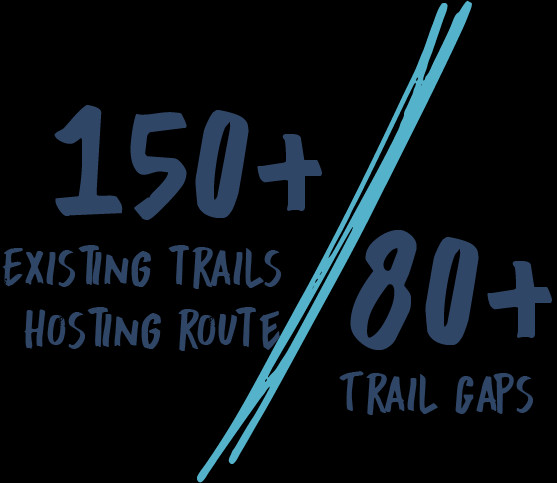 Great American Rail-Trail 2023 Infographic – 150 existing trails hosting route and 80 trail gaps
Infographic illustrating the network of trails and gaps in Great American Rail-Trail bike trail directions.
Planning Your Ride and Finding Bike Trail Directions
To effectively utilize the Great American Rail-Trail, especially for long-distance cycling, accessing detailed bike trail directions is essential. The interactive map provided by Rails-to-Trails Conservancy (RTC) is your primary resource.
Using the Interactive Map for Bike Trail Directions:
- Access the Map: Navigate to the Great American Rail-Trail interactive map.
- Explore Sections: Zoom in to areas you are interested in riding.
- Identify Trails: Click on trail segments to learn their names and access more information via TrailLink.
- Plan Segments: Piece together sections based on your desired distance and location, noting the connecting trails for seamless bike trail directions.
Remember to download the Great American Rail-Trail Branded Map for offline reference. This PDF map provides a comprehensive overview of the route, states, and major connecting trails, aiding in understanding the overall bike trail directions.
Conclusion: Your Cross-Country Bike Adventure Awaits
The Great American Rail-Trail is more than just a bike trail; it’s a vision of a connected nation, offering cyclists and adventurers the chance to experience the diverse landscapes of the United States. While fully completed bike trail directions for the entire 3,700+ miles are still in development, the existing sections and the detailed interactive map provide ample opportunity to explore and plan your cross-country cycling journey. Start exploring today, discover segments near you, and be part of the unfolding story of the Great American Rail-Trail!
Explore the Great American Rail-Trail map and begin planning your adventure now!