Embarking on a Bike Across The Us is a dream for many cyclists, a journey that promises adventure, stunning landscapes, and a profound connection with the country. For those seeking the quintessential cross-country cycling experience, the TransAmerica Bicycle Trail stands as the classic and most celebrated route. Established in 1976 as part of Bikecentennial, this iconic trail, meticulously mapped by the Adventure Cycling Association, stretches over 4,200 miles from the Pacific coast in Astoria, Oregon, to the Atlantic shore in Yorktown, Virginia. This guide dives deep into everything you need to know to plan your own unforgettable bike tour across America.
Discovering the TransAmerica Trail: A Coast-to-Coast Cycling Legacy
The TransAmerica Bicycle Trail isn’t just a route; it’s a piece of cycling history. Its origins trace back to 1973, born from the ambitious vision of Adventure Cycling Association’s co-founder during a ride from Alaska to Argentina. The idea was to create a transcontinental cycling route to celebrate the United States’ bicentennial. By 1976, this vision became a reality. Thanks to a massive mapping and guidebook effort, the TransAmerica Trail was officially launched as “Bikecentennial,” inviting cyclists to experience America in a unique and personal way.
The inaugural Bikecentennial event in 1976 was a resounding success, drawing around 4,000 cyclists, mostly young adults with limited long-distance cycling experience. Equipped with basic bikes and minimal gear, these pioneers set out in small groups, guided by Bikecentennial-trained leaders. Helmets were rare, and bikes were often entry-level, but the spirit of adventure and discovery was abundant. What they lacked in experience, they made up for in enthusiasm, forging lifelong memories and a deep appreciation for the American landscape and its people.
The impact of Bikecentennial and the TransAmerica Trail was profound. It wasn’t just a bike ride; it was a cultural phenomenon that resonated with a generation seeking authentic experiences. Cyclists from that era, and those who ride the trail today, often share a common sentiment: “I learned more about this country in 90 days than most people learn in a lifetime.” This enduring quote encapsulates the transformative power of cycling across America, highlighting the trail’s ability to foster a unique understanding of the nation’s diverse geography, history, and communities.
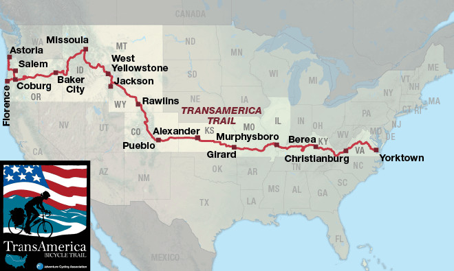 TransAmerica Bicycle Trail overview map
Overview map of the TransAmerica Bicycle Trail, showcasing the full route from Oregon to Virginia and the twelve detailed map sections.
Why Choose the TransAmerica Trail for Your Bike Across the US Adventure?
The TransAmerica Trail is more than just a line on a map; it’s a carefully curated journey that offers a balanced and enriching cross-country cycling experience. Here’s why it remains the premier choice for cyclists planning to bike across the US:
- Established and Well-Documented: Decades of refinement by the Adventure Cycling Association have resulted in detailed maps, guidebooks, and online resources. This extensive documentation provides cyclists with confidence and support throughout their journey, from route planning to daily navigation.
- Scenic Diversity: The trail traverses an incredible variety of landscapes, from the rugged Pacific coastline and lush forests of Oregon to the towering Rocky Mountains, the vast Great Plains, the rolling Ozark Mountains, the Appalachian range, and finally, the historic East Coast. Each section offers a unique visual and geographical experience.
- Rich in History and Culture: Beyond natural beauty, the TransAmerica Trail is steeped in American history. Cyclists encounter landmarks of westward expansion, Native American historical sites, Civil War battlefields, and colonial settlements. The route passes through charming small towns and vibrant cities, offering glimpses into the diverse cultures and communities that make up the US.
- Cyclist-Friendly Infrastructure: Having been a popular cycling route for decades, the TransAmerica Trail benefits from a network of cyclist-friendly services and accommodations. Many towns along the route are accustomed to welcoming touring cyclists, offering bike shops, campgrounds, cyclist journals in cafes, and warm hospitality.
- National Parks and Monuments: The route is strategically planned to include some of America’s most iconic national parks, such as Yellowstone and Grand Teton, offering opportunities for breathtaking detours and unforgettable sightseeing experiences.
Section-by-Section Guide to the TransAmerica Trail: Planning Your Ride
To make the 4,200-mile journey manageable, the TransAmerica Trail is divided into twelve detailed map sections. Each section offers its own unique character and challenges. Understanding these sections is crucial for effective planning.
Section 1: Astoria, OR to Coburg, OR (Pacific Beginnings)
Starting in Astoria, Oregon, a historic port city at the mouth of the Columbia River, Section 1 immediately immerses cyclists in the stunning beauty of the Pacific Northwest. Expect rolling hills reminiscent of San Francisco, breathtaking coastal views, and charming seaside towns. Highlights include the iconic Astoria Column, vast stretches of Pacific beaches, and numerous state parks. The route then turns inland, following the Willamette River Valley, passing through Eugene, the largest city in this section. Be prepared for steep ascents and descents along the coast and savor the fresh seafood.
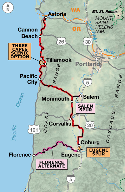 TransAmerica Trail Section 1 Map
Detail map of TransAmerica Trail Section 1, Astoria to Coburg, Oregon, highlighting coastal routes and the transition inland towards the Willamette Valley.
Section 2: Coburg, OR to Baker City, OR (Cascades and High Desert)
Section 2 marks a dramatic shift in landscape as you cycle eastward from the lush Willamette Valley into the drier terrain east of the Cascade Mountains. The iconic McKenzie Pass is a major highlight, offering stunning views of ancient lava fields and snow-capped volcanic peaks like the Three Sisters. Central and Eastern Oregon present a more arid, mountainous environment, requiring cyclists to carry extra water. The section culminates in Baker City, home to the must-visit National Historic Oregon Trail Interpretive Center, connecting your cycling journey to the pioneer spirit of westward expansion.
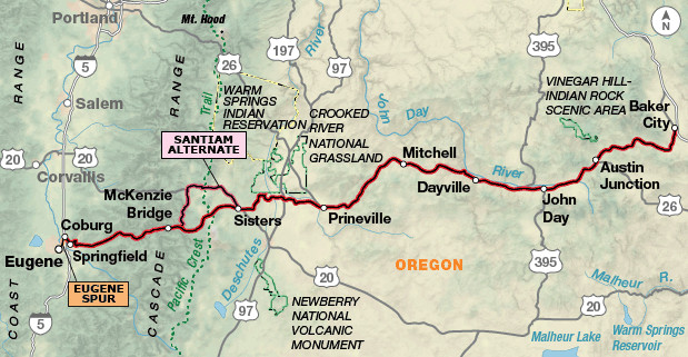 TransAmerica Trail Section 2 Map
Detail map of TransAmerica Trail Section 2, Coburg to Baker City, Oregon, showing the route climbing over McKenzie Pass and entering the high desert region.
Section 3: Baker City, OR to Missoula, MT (Rivers and Historic Trails)
Entering Idaho, Section 3 follows the scenic Little Salmon and Salmon Rivers, offering a pleasant riverside ride and opportunities to explore Native American historic sites. The route then traces the Middle Fork Clearwater and Lochsa Rivers, leading to the longest gradual ascent of the entire trip (around 70 miles). This culminates in Lolo Pass, marking the entry into Montana and the approach to Missoula. Missoula, home to Adventure Cycling Association headquarters, provides a welcoming haven for cyclists with its “cyclist’s lounge” and full-service amenities.
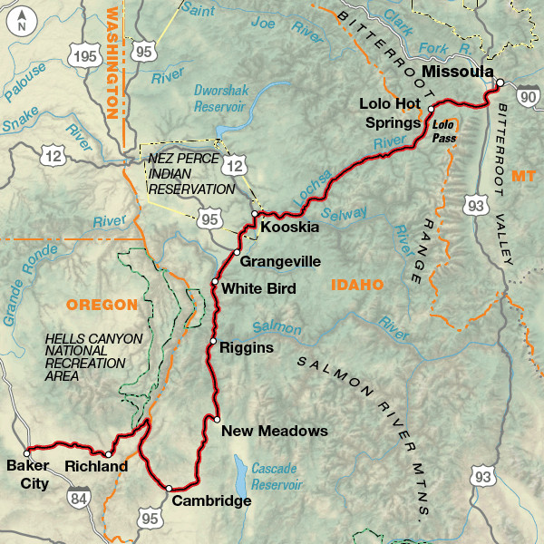 TransAmerica Trail Section 3 Map
Detail map of TransAmerica Trail Section 3, Baker City, Oregon to Missoula, Montana, illustrating the route along Idaho’s rivers and ascent to Lolo Pass.
Section 4: Missoula, MT to West Yellowstone, MT (Big Sky Country)
Montana’s “Big Sky Country” unfolds in Section 4, characterized by vast valleys, panoramic mountain views, and open skies. The route offers a mix of rolling hills and mountain passes, leading towards the grandeur of Yellowstone National Park. Consider taking the Old Darby and Gibbons Pass alternates for more secluded and challenging gravel riding experiences. This section sets the stage for the unparalleled natural beauty awaiting in Yellowstone and Grand Teton National Parks.
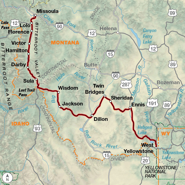 TransAmerica Trail Section 4 Map
Detail map of TransAmerica Trail Section 4, Missoula to West Yellowstone, Montana, depicting the open valleys and mountain passes of western Montana.
Section 5: West Yellowstone, MT to Rawlins, WY (Yellowstone and Grand Teton)
Section 5 is a highlight reel of natural wonders as it passes through Yellowstone and Grand Teton National Parks in Wyoming. Prepare to be awestruck by geysers, hot springs, abundant wildlife in Yellowstone, and the majestic Teton Range. Allocate extra days to explore these phenomenal parks, either by bike or by taking a break from cycling to hike and sightsee. Towns like Dubois and Lander offer a taste of the Wild West with their historic architecture and western-style hospitality. Consider the Teton Valley Alternate for a route that bypasses riding directly through Yellowstone National Park if you prefer to avoid park traffic.
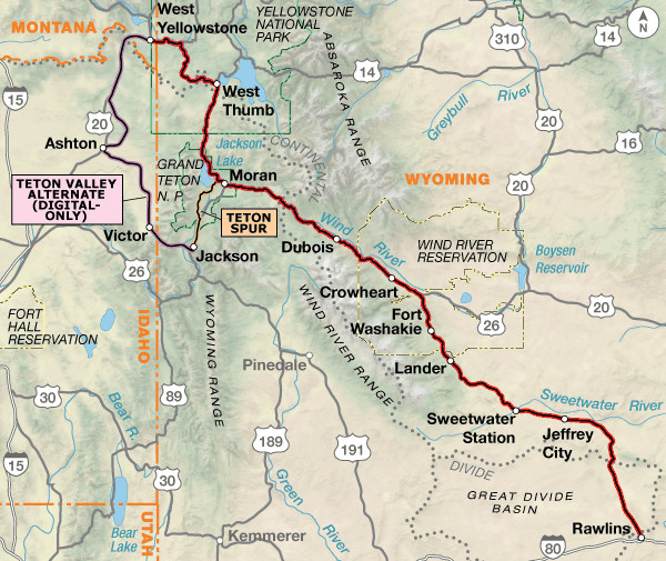 TransAmerica Trail Section 5 Map
Detail map of TransAmerica Trail Section 5, West Yellowstone, Montana to Rawlins, Wyoming, showcasing the route through Yellowstone and Grand Teton National Parks.
Section 6: Rawlins, WY to Pueblo, CO (Rocky Mountain Highs)
Entering Colorado, Section 6 brings a dramatic change in scenery as the landscape transitions from high desert to alpine. The route climbs into the heart of the Rocky Mountains, passing through touristy towns like Frisco and Breckenridge, ideal for rest days. The challenging ascent to Hoosier Pass, the highest point on the TransAmerica Trail at 11,542 feet, rewards cyclists with breathtaking panoramic views from the Continental Divide. As you descend from the Rockies, Royal Gorge Park offers thrilling layover options, from bridge walks to helicopter rides. Pueblo marks the halfway point of the TransAmerica Trail, a perfect place to celebrate this significant milestone.
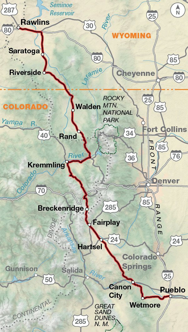 TransAmerica Trail Section 6 Map
Detail map of TransAmerica Trail Section 6, Rawlins, Wyoming to Pueblo, Colorado, illustrating the climb into the Rocky Mountains and over Hoosier Pass.
Section 7: Pueblo, CO to Alexander, KS (High Plains Transition)
Section 7 marks the transition from the mountainous Rockies to the vast Great Plains as you cycle eastward across Colorado and into western Kansas. The landscape becomes drier and more barren, emphasizing the importance of carrying extra water. This section is known for its expansive skies and the gradual flattening of terrain. Look for the “Skyscraper of the Plains” near Greensburg, Kansas, a unique roadside attraction. This section offers a taste of the wide-open spaces and agricultural heartland of America.
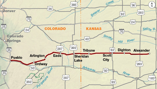 TransAmerica Trail Section 7 Map
Detail map of TransAmerica Trail Section 7, Pueblo, Colorado to Alexander, Kansas, showing the transition from the Rockies onto the High Plains.
Section 8: Alexander, KS to Girard, KS (Heartland Hospitality)
Cycling through central Kansas in Section 8, you’ll experience the quintessential American heartland. The terrain is generally flat, offering easier riding after the mountains. Kansas is renowned for its hospitality, and you’ll likely find welcoming communities and cyclist-friendly city parks. Don’t miss the Kansas Cosmosphere and Space Center in Hutchinson for a fascinating detour. Be prepared for potential heat and wind as you traverse this section of the Great Plains.
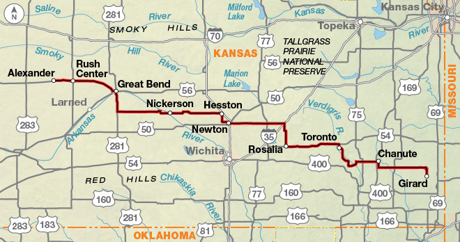 TransAmerica Trail Section 8 Map
Detail map of TransAmerica Trail Section 8, Alexander to Girard, Kansas, highlighting the flat terrain and heartland towns of central Kansas.
Section 9: Girard, KS to Murphysboro, IL (Ozark Foothills)
Section 9 brings a gradual change from the flat plains to the rolling terrain of western Missouri and the Ozark foothills. While still relatively flat compared to the Rockies or Appalachians, expect more elevation changes and winding roads. Missouri offers historical sites related to the Civil War and natural attractions like the Ozark National Scenic Riverways, perfect for canoeing and enjoying nature. As you approach Illinois, the landscape becomes hillier, foreshadowing the Ozark Mountains ahead.
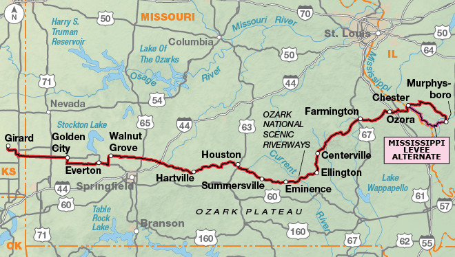 TransAmerica Trail Section 9 Map
Detail map of TransAmerica Trail Section 9, Girard, Kansas to Murphysboro, Illinois, illustrating the transition to rolling terrain and the Ozark foothills.
Section 10: Murphysboro, IL to Berea, KY (Ozark Rollercoaster and Caves)
Section 10 delves into the heart of the Ozark Mountains, known for their “rollercoaster” terrain with short, steep climbs and descents. This section can be physically demanding but also rewarding with scenic views and natural beauty. Highlights include Johnson’s Shut-Ins State Park, a unique natural waterpark, and Cave-In-Rock State Park on the Ohio River. In Kentucky, consider the Mammoth Cave Loop for a detour to explore the world’s longest cave system. Berea, Kentucky, marks the gateway to the Appalachian Mountains.
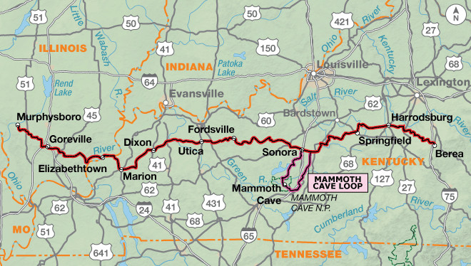 TransAmerica Trail Section 10 Map
Detail map of TransAmerica Trail Section 10, Murphysboro, Illinois to Berea, Kentucky, showing the hilly Ozark terrain and the approach to the Appalachian Mountains.
Section 11: Berea, KY to Christiansburg, VA (Appalachian Challenge)
Section 11 presents the most challenging climbing of the entire TransAmerica Trail as you traverse the Appalachian Mountains. Expect steep, relentless climbs and descents on narrow, winding roads. Breaks Interstate Park offers stunning canyon views, and Mount Rogers National Recreation Area provides opportunities for high-elevation riding. This section tests your endurance but rewards you with the rugged beauty of Appalachia.
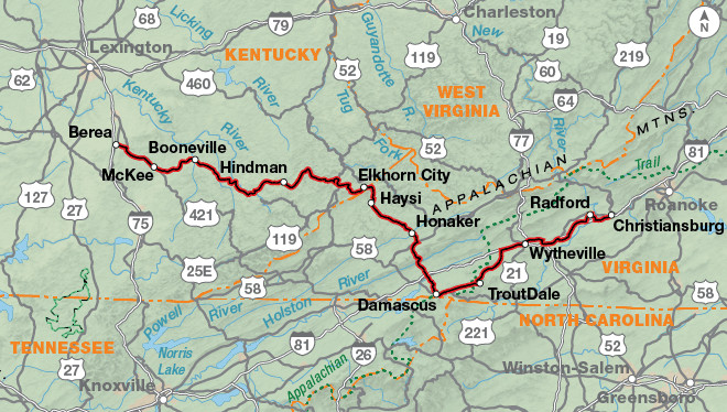 TransAmerica Trail Section 11 Map
Detail map of TransAmerica Trail Section 11, Berea, Kentucky to Christiansburg, Virginia, depicting the challenging climbs and descents through the Appalachian Mountains.
Section 12: Christiansburg, VA to Yorktown, VA (Historic Virginia Finale)
The final section, Section 12, offers a historical and scenic conclusion to your bike across the US. You’ll cycle along the Blue Ridge Parkway, enjoying stunning mountain vistas (be aware of potential closures and traffic). As you descend from the mountains, the terrain transitions to rolling hills and flatlands of the Virginia Piedmont and Tidewater regions. The route is rich in American Revolutionary War history, culminating in Yorktown, situated on the Chesapeake Bay, the official end of the TransAmerica Trail. Highlights include Colonial Williamsburg, Monticello (Thomas Jefferson’s home), and Richmond National Battlefield Park. Consider the Richmond Alternate for a detour through the state capital.
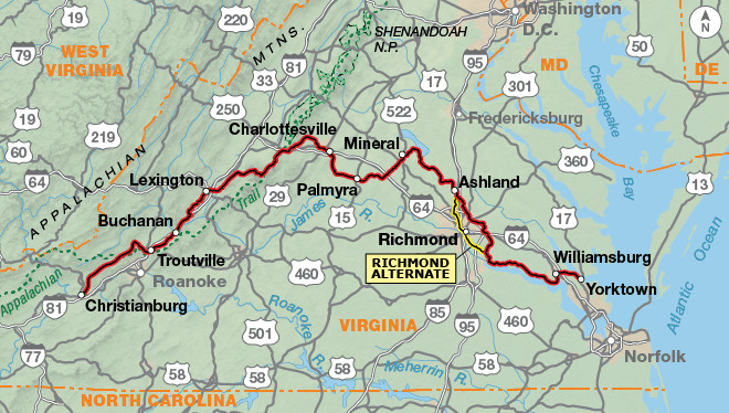 TransAmerica Trail Section 12 Map
Detail map of TransAmerica Trail Section 12, Christiansburg to Yorktown, Virginia, illustrating the descent from the Blue Ridge Parkway and the route through historic Virginia.
Planning Your TransAmerica Trail Bike Tour: Essential Considerations
Successfully biking across the US on the TransAmerica Trail requires careful planning and preparation. Here are key factors to consider:
- Time Commitment: Plan for approximately three months to complete the entire route. Some cyclists may finish faster, but allowing ample time ensures a more relaxed pace and opportunities for sightseeing and rest days.
- Best Time to Ride: The optimal riding season is from May to September. This timeframe generally avoids extreme weather conditions across most of the route. Be aware of potential snow in the Rocky Mountains, even in early summer, and summer heat in the Great Plains.
- Direction of Travel: While the prevailing winds are generally from west to east, local wind patterns can be unpredictable. Cyclists ride the route in both directions, so choose based on personal preference and seasonal considerations.
- Gear and Bike Choice: A reliable touring bike is essential. Consider sturdy tires, comfortable saddle, and ample gear carrying capacity. Pack for all types of weather, including rain gear and layers for varying temperatures. Self-sufficiency in bike repair is also important.
- Navigation: Adventure Cycling Association maps are highly recommended. They provide detailed route information, elevation profiles, points of interest, and service listings. Consider using a GPS device as a supplementary navigation tool.
- Accommodation and Camping: Camping options range from private campgrounds to city parks, state and national parks, and national forests. Kansas and Missouri are known for city park camping. Food and lodging are more abundant in the eastern sections of the trail. Consider joining Warmshowers for potential homestays with fellow cyclists.
- Budget: Costs vary depending on your travel style (camping vs. hotels, eating out vs. cooking). Factor in expenses for food, accommodation, bike maintenance, gear, and potential park entrance fees.
- Physical Fitness and Training: Biking across the US is a significant physical challenge. Prepare with long-distance cycling training rides and build your endurance gradually.
- Safety: Be aware of traffic, especially on busier roads. Wear bright clothing and use safety lights. Carry a first-aid kit and know basic bike repair. Inform someone of your itinerary and check in regularly. Be mindful of wildlife, especially in national parks.
Route Highlights: Must-See Attractions Along the TransAmerica Trail
Beyond the stunning landscapes, the TransAmerica Trail is dotted with numerous points of interest and attractions. Here are some highlights to look forward to:
- Pacific Coast (Section 1): Oregon’s dramatic coastline, beaches, and charming seaside towns.
- Tillamook Cheese Factory (Section 1): A delicious stop for cheese lovers.
- McKenzie Pass (Section 2): Spectacular volcanic landscapes and mountain views.
- National Historic Oregon Trail Interpretive Center (Section 3): Learn about pioneer history.
- Yellowstone and Grand Teton National Parks (Section 5): Iconic natural wonders.
- Hoosier Pass (Section 6): Summit of the TransAmerica Trail with breathtaking views.
- Royal Gorge Bridge and Park (Section 6): Thrilling bridge and gorge experiences.
- Ozark National Scenic Riverways (Section 9): Pristine rivers and natural beauty.
- Mammoth Cave National Park (Section 10): World’s longest cave system (detour).
- Blue Ridge Parkway (Section 12): Scenic mountain drive (cycling allowed).
- Colonial Williamsburg and Yorktown (Section 12): Historic sites of the American Revolution.
Riding Conditions and Climate Considerations
The TransAmerica Trail presents diverse riding conditions and climates across its vast expanse. Be prepared for:
- Western Sections (Oregon, Idaho, Montana, Wyoming, Colorado): Expect significant elevation changes, mountain passes, and varied terrain from coastal ranges to high desert and alpine environments. Carry extra water, especially in drier regions. Weather can be unpredictable, with potential for rain, heat, and even snow at higher elevations.
- Great Plains (Kansas): Generally flat terrain with long stretches of open road. Wind can be a significant factor. Summer heat can be intense, requiring early morning or evening riding to avoid midday extremes.
- Ozarks and Appalachians (Missouri, Illinois, Kentucky, Virginia): Rolling to hilly terrain, especially in the Ozarks and Appalachians. Expect shorter, steeper climbs compared to the Rockies. Humidity can be high in the eastern sections, particularly in summer. Be aware of narrow roads and limited visibility in mountainous areas.
- Virginia: Surprisingly, Virginia has significant total elevation gain, particularly in the Appalachian region and Blue Ridge Parkway. The Tidewater region near the coast is flatter but can have heavy traffic. Marine climate with potential for rain and humidity.
Always check updated weather forecasts and road conditions before and during your trip. Be prepared for a range of temperatures and weather patterns across different sections of the trail.
Embark on Your Bike Across the US Adventure
Biking across the US on the TransAmerica Trail is an extraordinary undertaking, a journey of self-discovery, physical challenge, and immersion in the diverse tapestry of America. With careful planning, proper preparation, and a spirit of adventure, you can experience the unparalleled rewards of this classic cross-country cycling route. Start planning your TransAmerica Trail adventure today and create memories that will last a lifetime. Visit the Adventure Cycling Association website for detailed maps, resources, and to connect with the vibrant community of TransAmerica Trail cyclists.