
Embarking on a Bike Ride Across America is a dream for many cyclists. Imagine the open road, the changing landscapes, and the personal journey of traversing an entire continent on two wheels. For those seeking the quintessential American cycling adventure, the TransAmerica Trail stands as a legendary route, steeped in history and brimming with breathtaking scenery.
This guide delves into everything you need to know about planning your own unforgettable bike ride across America along the TransAmerica Trail. From its historic origins to detailed section breakdowns, route highlights, and essential riding conditions, we’ll equip you with the knowledge to conquer this iconic cycling path.
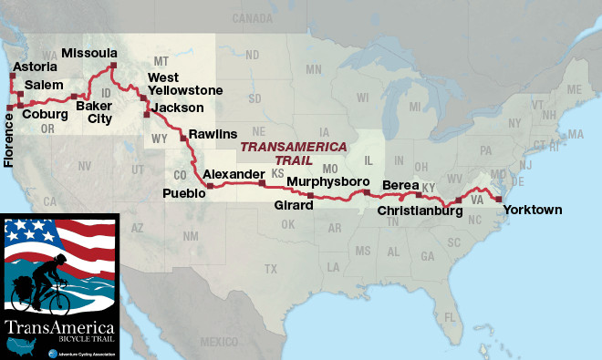 TransAmerica Bicycle Trail map overview
The Historic Roots of the TransAmerica Trail
The story of the TransAmerica Bicycle Trail is as compelling as the ride itself. Born from the ambitious vision of Adventure Cycling Association’s co-founder during a Pan-American cycling expedition from Alaska to Argentina in 1973, the trail was conceived as a unique way to celebrate the United States’ bicentennial in 1976. This ambitious idea blossomed into “Bikecentennial,” a landmark event that saw the creation of maps and guidebooks for a coast-to-coast cycling route, ready just in time for the bicentennial celebrations.
The Bikecentennial event was a resounding success, attracting over 4,000 cyclists, mostly in their twenties and new to long-distance cycling, to experience a bike ride across America. Organized into groups led by Bikecentennial-trained leaders, these pioneers set off with basic gear and an adventurous spirit. Helmets were scarce, and bikes were often entry-level, but the lack of fancy equipment didn’t diminish their ambition. They sought an experience of a lifetime, and that’s precisely what they found.
The impact of Bikecentennial and the TransAmerica Trail was profound. Cyclists from that era, and those who ride the trail today, often echo the sentiment: “I learned more about this country in 90 days than most people learn in a lifetime.” This enduring quote encapsulates the transformative power of a bike ride across America on the TransAmerica Trail – a journey of self-discovery and deep connection with the diverse tapestry of the nation.
Your Cross-Country Cycling Classic: Exploring the TransAmerica Trail Route
The TransAmerica Trail is more than just a route; it’s a meticulously crafted pathway through the heart of America. Spanning approximately 4,200 miles from Astoria, Oregon, to Yorktown, Virginia, it offers a diverse and challenging bike ride across America, traversing ten states and a remarkable array of landscapes. From the Pacific Coast to the Appalachian Mountains, the trail showcases the geographical and cultural richness of the United States.
One of the unique aspects of the TransAmerica Trail is its established history and the cycling community that has grown around it. Many businesses along the route, from cafes to accommodations, maintain journals filled with entries from cyclists who have ridden before you. These journals provide a unique cyclist’s history of the route, offering insights, tips, and encouragement from fellow adventurers – a testament to the shared experience of a bike ride across America.
Plan for approximately three months to fully appreciate your bike ride across America on the TransAmerica Trail. While some cyclists complete it faster, a more leisurely pace allows for sightseeing and soaking in the experience.
Section 1: Astoria, OR to Coburg, OR (224.5 miles)
Your bike ride across America begins in Astoria, Oregon, a charming coastal town reminiscent of a miniature San Francisco with its hilly terrain. The Astoria Column offers panoramic views well worth the initial uphill pedal. Section 1 is characterized by stunning Pacific beaches, exceptional state parks, and the rewarding climbs and descents of the Oregon coast, along with abundant fresh seafood. As you turn inland, the route follows the scenic Willamette River Valley, leading you to Eugene, the largest city in Oregon along the trail.
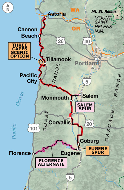 TransAmerica Trail Section 1 Map
Section 2: Coburg, OR to Baker City, OR (341.0 miles)
Leaving the lush greenery of western Oregon, Section 2 takes you eastward across the Cascade Mountains. The dramatic transition is evident as you ride into the drier terrain after conquering McKenzie Pass. This pass is a highlight, cutting through an ancient lava field and offering breathtaking vistas of the Three Sisters and other volcanic peaks. Central and eastern Oregon present a more arid, mountainous landscape, emphasizing the need to carry ample water. Baker City marks the end of this section, and a visit to the National Historic Oregon Trail Interpretive Center is highly recommended, providing context to the pioneering spirit you’ll embody on your bike ride across America.
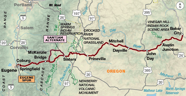 TransAmerica Trail Section 2 Map
Section 3: Baker City, OR to Missoula, MT (408.4 miles)
Idaho welcomes you in Section 3 with a beautiful ride alongside the Little Salmon and Salmon rivers. This section offers opportunities to explore Native American historic sites, adding cultural depth to your bike ride across America. The route then follows the Middle Fork Clearwater and Lochsa rivers, tracing a long, gradual ascent of approximately 70 miles. This climb culminates at Lolo Pass, marking your entry into Montana and the approach to Missoula. Missoula, a vibrant college town and home to Adventure Cycling Association headquarters, is a significant stop. The “cyclist’s lounge” at headquarters and town amenities provide a welcome respite and resources for your journey.
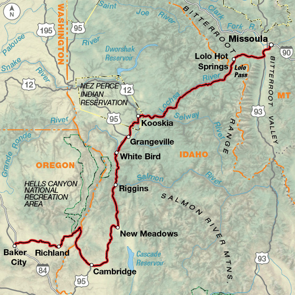 TransAmerica Trail Section 3 Map
Section 4: Missoula, MT to West Yellowstone, MT (329.8 miles)
Montana’s grandeur unfolds in Section 4, with expansive valleys and mountain passes framing your bike ride across America. Prepare for stunning panoramas as you cycle through Big Hole National Battlefield, a poignant historical site. The route leads you closer to the iconic Yellowstone National Park, culminating in West Yellowstone, Montana, the gateway to the park. Consider spending extra time here to explore the natural wonders of Yellowstone and Grand Teton National Parks in the upcoming section.
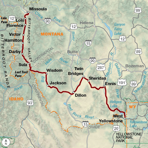 TransAmerica Trail Section 4 Map
Section 5: West Yellowstone, MT to Rawlins, WY (350.0 miles)
Section 5 immerses you in the unparalleled beauty of Yellowstone and Grand Teton National Parks in Wyoming – true highlights of any bike ride across America. Allocate extra days to fully experience these phenomenal parks. Towns like Dubois and Lander reflect the spirit of the American West with their historic architecture and hearty cuisine. Remember that cyclist traffic and RV traffic can be heavy within the parks, especially during peak season. Consider riding early in the day to avoid congestion.
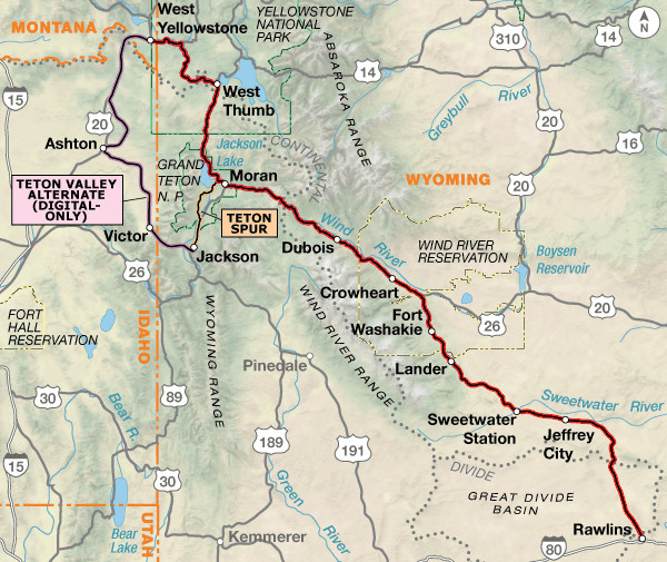 TransAmerica Trail Section 5 Map
Section 6: Rawlins, WY to Pueblo, CO (389.5 miles)
The landscape transforms dramatically in Section 6, shifting from high desert to alpine scenery as you approach Kremmling, Colorado. Frisco and Breckenridge in Summit County offer tourist-friendly layover options. Prepare for a challenging climb to Hoosier Pass, reaching 11,542 feet and the Continental Divide amidst snow-capped peaks – the highest point on the TransAmerica Trail. As you descend from the Rockies, Royal Gorge Park offers another potential layover with attractions like the Arkansas River bridge and helicopter tours. Pueblo marks the halfway point of the TransAmerica Trail and a well-deserved celebratory stop on your bike ride across America, with bike shops and dining options to replenish.
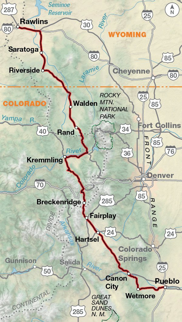 TransAmerica Trail Section 6 Map
Section 7: Pueblo, CO to Alexander, KS (287.8 miles)
Section 7 signals a shift in terrain as you leave the Rockies and enter the eastern plains of Colorado and western Kansas. The landscape becomes drier and more barren, emphasizing the importance of carrying extra water. Around Haswell, Colorado, catch your last glimpse of the Rocky Mountains fading into the horizon. City parks in Kansas often offer welcome swimming pools for respite from the heat. Early morning and evening riding may be necessary to avoid the midday sun.
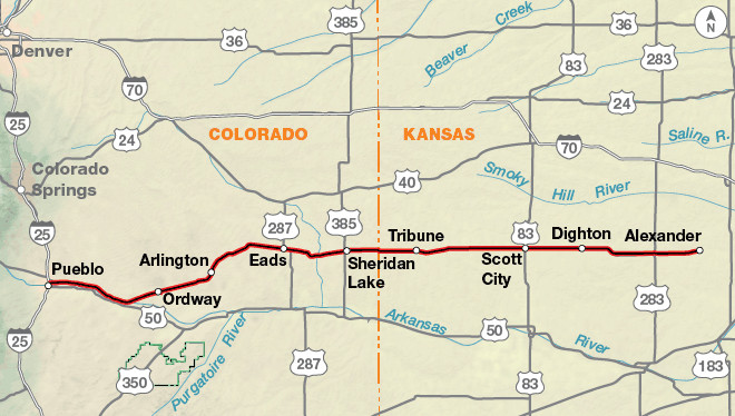 TransAmerica Trail Section 7 Map
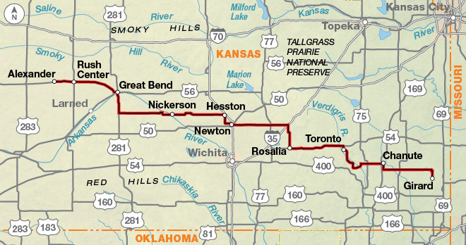
Section 8: Alexander, KS to Girard, KS (326.1 miles)
Kansas hospitality shines in Section 8 as you cycle through the heart of the Great Plains. The terrain is predominantly flat, offering a change of pace from the mountains. Overnight stays in city parks are common in Kansas, often accompanied by refreshing dips in public swimming pools. Don’t miss the famous pies at Cooky’s in Golden City, Missouri, a local culinary highlight. The flat terrain will soon give way to the rolling hills of Missouri.
 TransAmerica Trail Section 8 Map
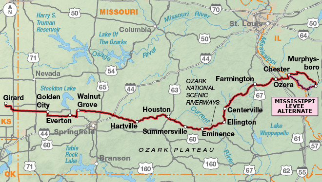
Section 9: Girard, KS to Murphysboro, IL (411.0 miles)
Missouri’s rolling hills and the Ozarks mark a significant terrain change in Section 9. Prepare for “roller-coaster riding” as the flat plains transition to steeper inclines. Missouri offers Civil War history, canoeing opportunities in Eminence, and the natural swimming hole at Johnson’s Shut-Ins State Park. As you approach the Mississippi River, the terrain flattens again. Crossing the Mississippi at Chester, Illinois, leads you into Carbondale, another college town, and the gateway to the eastern portion of your bike ride across America.
 TransAmerica Trail Section 9 Map
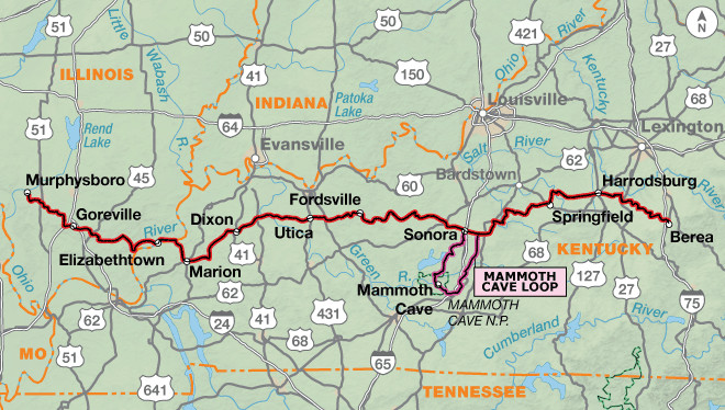
Section 10: Murphysboro, IL to Berea, KY (400.4 miles)
Section 10 takes you across the Ohio River via ferry into Kentucky. Enjoy the rolling hills, white-fenced farms, and woodlands of Kentucky. The evenings in Kentucky campsites are often illuminated by fireflies, adding a touch of magic to your bike ride across America. Berea serves as the gateway to the Appalachian Mountains. A detour south of the route leads to Mammoth Cave National Park, the world’s longest cave system, a worthwhile side trip for cave enthusiasts.
 TransAmerica Trail Section 10 Map
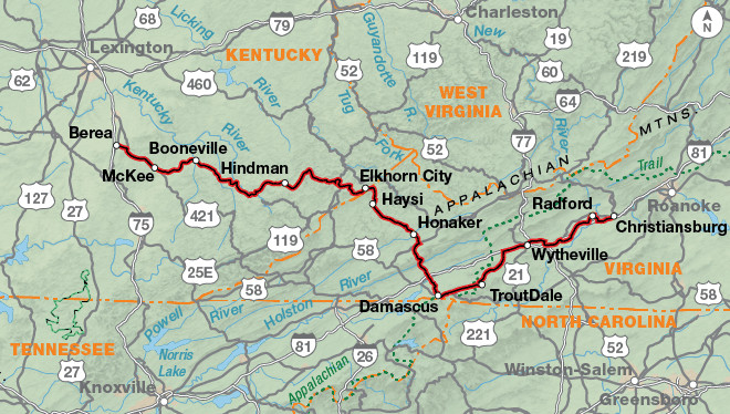
Section 11: Berea, KY to Christiansburg, VA (370.5 miles)
The Appalachian Mountains present a new challenge in Section 11. Expect ascents and descents through these ancient mountains. The route includes a section of the scenic Blue Ridge Parkway in Virginia. The mountains gradually transition to rolling hills as you continue eastward. Breaks Interstate Park offers stunning canyon views and marks your passage into Virginia.
 TransAmerica Trail Section 11 Map
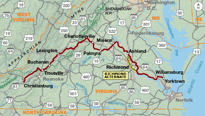
Section 12: Christiansburg, VA to Yorktown, VA (365.9 miles)
The final section, Section 12, guides you through the rolling hills and flatlands of Virginia, rich in American history. The route passes through lush plantations and farmlands, leading you to Colonial Williamsburg, a highlight for history buffs. The TransAmerica Trail culminates in Yorktown, situated on the Chesapeake Bay, marking the triumphant end of your bike ride across America. Reflect on your incredible journey as you reach the Atlantic coast.
 TransAmerica Trail Section 12 Map
Route Highlights: Unforgettable Stops on Your Bike Ride Across America
The TransAmerica Trail is punctuated with incredible highlights, ensuring a memorable bike ride across America. Here are some must-see locations along the route, organized by the Adventure Cycling Association section maps:
Section 1 (Oregon):
- Pacific Coast: The dramatic starting point of your journey.
- Tillamook Cheese Factory: A classic Oregon experience.
- Chachalu Museum: Explore Confederated Tribes of Grand Ronde history.
- Fort Yamhill State Heritage Area: History of the Grand Ronde Reservation.
- Oregon Dunes National Recreation Area (Florence Alternate): Coastal dune landscapes.
- McKenzie Pass (Section 2): Volcanic landscape and Cascade Mountain views.
Section 2 (Oregon):
- Smith Rock State Park: Rock climbing mecca and scenic views.
- John Day Fossil Beds National Monument: Paleontological wonders.
- National Historic Oregon Trail Interpretive Center (Section 3): Oregon Trail history.
Section 3 (Idaho/Montana):
- Nee-Me-Poo Trail: Nez Perce National Historic Trail segment.
- Nez Perce National Historic Park: Learn about Nez Perce culture and history.
- Travelers’ Rest State Park: Lewis and Clark Expedition campsite.
Section 4 (Montana):
- Bannack State Park: Montana’s first territorial capital ghost town.
- Big Hole Battlefield National Monument: Site of a significant Nez Perce War battle.
- Yellowstone National Park (Section 5): Geothermal wonders and wildlife.
- Grand Teton National Park (Section 5): Majestic mountain scenery.
Section 5 (Wyoming):
- Hot Sulphur Springs State Wildlife Area (Section 6): Natural hot springs.
- Hoosier Pass (Section 6): Continental Divide crossing and high-altitude views.
- Royal Gorge Bridge and Park (Section 6): Suspension bridge over the Arkansas River.
- “Skyscraper of the Plains” (Section 7): Castle Rock formation in Kansas.
Section 7 & 8 (Kansas):
- Quivira National Wildlife Refuge (Section 8): Birdwatching and wetlands.
- Kansas Cosmosphere and Space Center (Section 8): Space exploration museum.
Section 9 (Missouri):
- Alley Spring & Mill, Ozark National Scenic Waterways: Historic mill and spring.
- Johnson’s Shut-Ins State Park (Section 10): Natural water park and geological formations.
- Cave-In-Rock State Park (Section 10): Historic cave along the Ohio River.
- Mammoth Cave National Park (Mammoth Cave Loop, Section 10): World’s longest cave system.
- Lincoln Homestead State Park (Section 10): Preserved home of Abraham Lincoln’s father.
Section 11 (Kentucky/Virginia):
- Breaks Interstate Park: “Grand Canyon of the South”.
- Mount Rogers National Recreation Area: Highest point in Virginia.
- Blue Ridge Parkway (Section 12): Scenic mountain drive.
- Monticello, Home of President Thomas Jefferson (Section 12): Jefferson’s iconic home.
- Ash Lawn, Home of President James Monroe (Section 12): Monroe’s historic estate.
- Richmond National Battlefield Park (Section 12): Civil War battlefields.
- Colonial National Historical Park (Section 12): Jamestown, Yorktown, and Williamsburg.
- Williamsburg, Virginia (Section 12): Living history museum of colonial life.
Riding Conditions and Climate: Preparing for Your TransAmerica Bike Tour
Understanding the riding conditions and climate along the TransAmerica Trail is crucial for a successful bike ride across America. The route traverses diverse geographical regions, each presenting unique challenges and weather patterns.
Western Sections (Oregon, Idaho, Montana, Wyoming, Colorado):
- Terrain: Expect significant elevation changes, especially in the Cascade and Rocky Mountains. While some river valleys offer flatter stretches, climbing is a regular part of the western sections. Passes in the Rockies are generally long but not excessively steep.
- Climate: Western Oregon experiences a marine climate with potential for heavy rain even in summer. Fog is common, especially near the coast. East of the Cascades, the climate becomes drier and hotter, particularly in eastern Oregon and Idaho’s Snake River Canyon. Montana’s climate varies significantly east and west of the Continental Divide, with thunderstorms and hailstorms possible in summer. Wyoming and Colorado high-altitude regions have cool, semi-arid climates with potential for strong winds and afternoon thunderstorms.
- Riding Conditions: Road surfaces are generally good on main highways, but shoulders may be narrow or non-existent in places. Traffic can be heavy on major routes, especially near tourist areas and during peak seasons. Be prepared for cattle guards, gravel sections, and potential road closures due to snow at higher elevations, particularly McKenzie Pass and Hoosier Pass.
Central Sections (Kansas, Missouri, Illinois, Kentucky):
- Terrain: Kansas is predominantly flat, transitioning to rolling hills in western Missouri and steeper, “roller-coaster” terrain in the Ozarks. Southern Illinois and western Kentucky feature ridges and valleys. The Knobs region of Kentucky presents conical hills. As you approach the Appalachians, the terrain becomes significantly hillier.
- Climate: Kansas and Missouri experience a continental climate with changeable weather. Winds are prevalent on the plains. Summer temperatures can be hot, with thunderstorms common. Humidity increases eastward. Southern Illinois and Kentucky have humid continental climates with warm, humid summers and potential for thunderstorms and flash floods.
- Riding Conditions: Roads in Kansas are generally good, often county roads with minimal traffic and no shoulders. Missouri roads can be narrower and deteriorating in places. Ozark roads are winding and hilly with limited visibility. Southern Illinois and Kentucky roads are often narrow and shoulderless, with potential for rumble strips and loose dogs in rural areas. Traffic increases near towns and recreational areas.
Eastern Sections (Virginia):
- Terrain: The Appalachians in Kentucky and Virginia are characterized by steep, relentless climbs and descents, often more challenging than the taller but gentler Rockies. Central Virginia transitions to rolling hills in the Piedmont and flatter terrain in the Tidewater region.
- Climate: Appalachia experiences westerly winds bringing storms in both summer and winter. Summers are warm and humid with frequent thunderstorms. Fog can be common in the highlands. Virginia Piedmont and Tidewater have marine climates with moderate temperatures, higher precipitation, and humid summers. Flooding is a potential concern.
- Riding Conditions: Appalachian roads are often narrow, shoulderless, and in varying condition with broken pavement and gravel. Traffic is generally light in backcountry areas, but can be heavy near tourist destinations and towns. The Blue Ridge Parkway offers shoulderless but scenic riding with no commercial traffic. Virginia Piedmont and Tidewater roads can be narrow and poor quality, with heavier traffic near cities and in the Historic Triangle.
Best Time to Ride:
The TransAmerica Trail is generally best ridden from May through September. This timeframe offers the most favorable weather conditions across the majority of the route. Be aware that snow can occur in the Rocky Mountains even in summer, and mountain passes like McKenzie and Hoosier Pass may be closed or have limited access early in the season.
Camping and Accommodation:
Camping options vary greatly along the TransAmerica Trail. You’ll find small private campgrounds, city parks, state and national parks, national forests, and occasional hospitality from locals. Camping is more limited in the western sections, particularly through eastern Oregon and Kansas, requiring more planning and carrying extra water. Camping options improve in the Rockies and eastward. Kansas is known for its hospitality and city park camping. From Missouri to Virginia, food, water, and overnight accommodations are more abundant.
Consider utilizing resources like Warmshowers, a hospitality network for cyclists, for additional accommodation options and community connections.
Essential Resources for Planning Your Bike Ride Across America
Planning a bike ride across America is a significant undertaking. Here are essential resources to help you prepare for your TransAmerica Trail adventure:
- Adventure Cycling Association: The definitive resource for TransAmerica Trail maps, guidebooks, membership, and route updates. Their website (www.adventurecycling.org) is invaluable for planning and information.
- TransAmerica Trail Maps and Guidebooks: Detailed maps and guidebooks from Adventure Cycling are essential for navigation, route information, services, and points of interest.
- Warmshowers: A global hospitality exchange for touring cyclists, offering free accommodation and connections with fellow cyclists (www.warmshowers.org).
- Route Updates and Corrections: Always check the Adventure Cycling website for the latest map updates and corrections to ensure you have the most current route information.
- Online Cycling Forums and Communities: Connect with other cyclists who have ridden the TransAmerica Trail for firsthand advice, tips, and support.
- Gear Lists and Packing Guides: Research recommended gear lists specifically for long-distance cycling and bike touring to ensure you are properly equipped for the journey.
- Climate and Weather Resources: Utilize weather websites and resources to monitor weather conditions along your planned route and adjust your plans accordingly.
- Bike Shops and Services Directory: Identify bike shops and service locations along the route for potential repairs and maintenance.
Embarking on a bike ride across America on the TransAmerica Trail is a life-changing experience. With careful planning, preparation, and a spirit of adventure, you can conquer this iconic route and create memories that will last a lifetime. Start planning your epic cycling journey today!