
Connecticut, a state steeped in history and brimming with natural beauty, offers a fantastic network of trails perfect for cyclists of all levels. From scenic coastal routes to tranquil wooded paths, the “Constitution State” provides diverse landscapes to explore on two wheels. Originally vital transportation arteries for railroads and canals, these corridors have been repurposed into picturesque trails, inviting bikers, walkers, and nature enthusiasts to enjoy the outdoors. Whether you’re a local seeking a weekend adventure or a visitor eager to discover Connecticut’s charm, the state’s bike trails promise memorable experiences. Many of these trails are shaded by lush forests, offering a cool escape during summer and a vibrant spectacle of colors in the fall, making them ideal for year-round enjoyment. Connecticut also plays a significant role in long-distance trail networks, hosting 98 miles of the expansive 3,000-mile East Coast Greenway and segments of the New England Rail-Trail Network, further solidifying its status as a premier destination for trail enthusiasts. Let’s dive into some of the top bike trails Connecticut has to offer.
1. Air Line State Park Trail
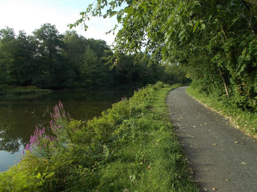
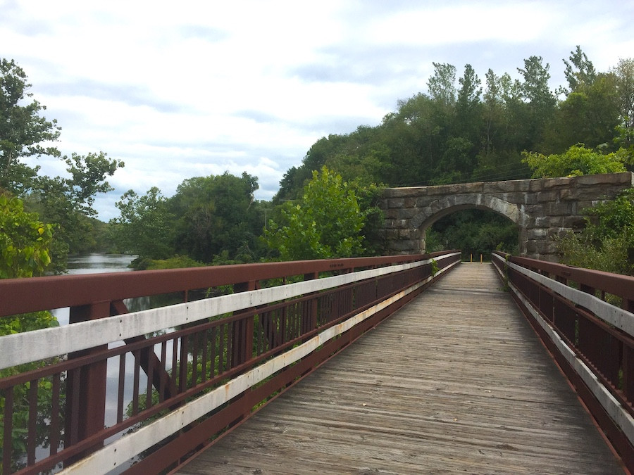 Cyclists enjoy the Air Line State Park Trail in Connecticut, surrounded by lush greenery.
The Air Line State Park Trail is a favorite escape for Connecticut residents seeking outdoor adventures. Named after the historic New York and Boston Air Line Railroad, this trail stretches for 55 miles, albeit with a few breaks, from the Massachusetts border in northeastern Connecticut towards the central part of the state near Middletown. Cyclists will encounter a mixed surface of gravel, ballast, and crushed rock, which can present a somewhat rugged ride in certain sections. However, the captivating forested scenery, especially when adorned with the vibrant hues of autumn, creates a truly rewarding journey.
Trail Highlights:
- Length: 55 miles (with gaps)
- Surface: Gravel, ballast, crushed rock
- Location: Northeast to central Connecticut
- Counties: Middlesex, New London, Tolland, Windham
- Connections: Connects with the Hop River State Park Trail in Willimantic.
- Points of Interest: Connecticut Eastern Railroad Museum in Willimantic, access to the East Coast Greenway and New England Rail-Trail Spine Network.
- Best Time to Visit: Fall for foliage, summer for shade.
- Suitable For: Intermediate to experienced cyclists due to varied terrain. Mountain bikes or hybrid bikes recommended.
The trail’s midpoint in Willimantic offers a historical treat for visitors at the Connecticut Eastern Railroad Museum. Furthermore, the Air Line State Park Trail acts as a vital component of both the six-state New England Rail-Trail Spine Network and the extensive East Coast Greenway, which spans from Maine to Florida, making it a significant trail for long-distance cycling enthusiasts.
2. Hop River State Park Trail
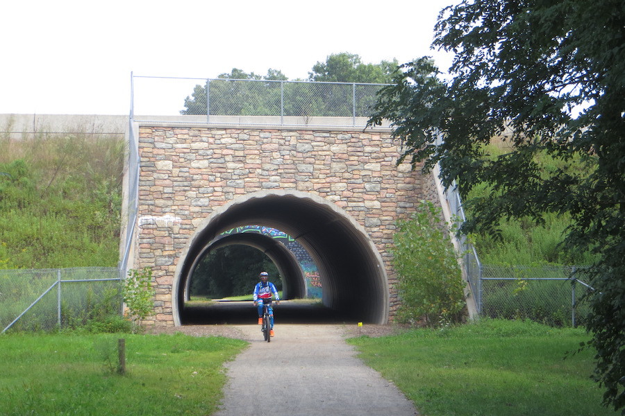
 A cyclist rides through a tunnel on the Hop River State Park Trail in Connecticut, showcasing the trail's unique features.
The Hop River State Park Trail, located in eastern Connecticut, offers a unique and engaging 20-mile journey. Trail users will be delighted to discover three tunnels and a charming covered bridge as they traverse this route. The trail surface, primarily crushed stone, meanders through secluded woodlands, interspersed with dramatic railroad cuts that provide refreshing coolness in the summer heat and stunning ice formations during winter.
Trail Highlights:
- Length: 20 miles
- Surface: Crushed stone
- Location: Eastern Connecticut, between Manchester and Willimantic
- Counties: Hartford, Tolland
- Unique Features: Three tunnels, one covered bridge, follows the Hop River.
- Connections: Intersects with Vernon Rails-to-Trails (Rockville Spur) in Vernon and Air Line State Park Trail in Willimantic. Part of the East Coast Greenway.
- Points of Interest: Colonial-era villages along the route, scenic river views.
- Best Time to Visit: Summer for cool tunnels and shade, winter for ice formations, fall for foliage.
- Suitable For: All skill levels, comfortable for families. Hybrid or mountain bikes recommended for crushed stone surface.
Following the course of the Hop River and its tributaries between Manchester and Willimantic, the trail forms another segment of the East Coast Greenway. Many of the villages dotted along the trail’s path boast historical roots dating back to Colonial times, adding a layer of historical intrigue to the scenic ride. The Hop River State Park Trail conveniently connects with the 4.2-mile Vernon Rails-to-Trails (Rockville Spur) in Vernon and the extensive 55-mile Air Line State Park Trail in Willimantic, offering opportunities for extended cycling adventures.
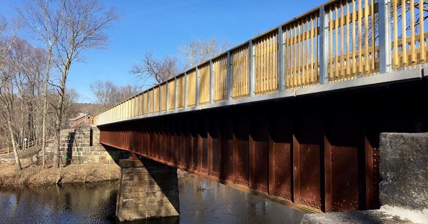 The bridge where the Hop River Trail and Air Line Trail meet over the Willimantic River in Windham, Connecticut.
3. Vernon Rails-to-Trails (Hop River State Park Rockville Spur)
 The Vernon Rails-to-Trails in Connecticut, showcasing a paved section suitable for various bikes.
For those interested in exploring the historical ambiance of Rockville in northern Connecticut, the Vernon Rails-to-Trails’ Rockville Spur offers an excellent opportunity. This 4.2-mile crushed-stone trail branches off from the Hop River State Park Trail in Vernon and leads towards Rockville, a town with a rich history in textile manufacturing.
Trail Highlights:
- Length: 4.2 miles
- Surface: Crushed stone
- Location: Vernon to Rockville, northern Connecticut
- County: Tolland
- Connections: Spur off the Hop River State Park Trail.
- Points of Interest: Tankerhoosen River, National Register Historic District in Rockville, Vernon Rails-to-Trails trailhead with historical information.
- Best Time to Visit: Spring to fall for pleasant weather and historical exploration.
- Suitable For: All skill levels, families, history enthusiasts. Hybrid or mountain bikes recommended for crushed stone.
The trail features a scenic footbridge crossing over the Tankerhoosen River and continues through a charming wooded corridor, eventually reaching the National Register of Historic Places district in Rockville. Here, visitors can admire architecture reminiscent of the 1800s, reflecting the town’s prosperous textile manufacturing era. At the Vernon Rails-to-Trails trailhead in Vernon, visitors can delve into the local history of textile and railroad industries, enriching their trail experience.
4. Farmington Canal Heritage Trail
 A paved section of the Farmington Canal Heritage Trail in Connecticut, ideal for road biking and leisurely rides.
The Farmington Canal Heritage Trail tells a story of evolution, from a canal to a railroad and finally to a trail. Stretching 56.5 miles, it is the longest paved trail in Connecticut, beginning near Yale University’s urban campus in New Haven and transitioning to a more rural setting as it extends north towards the Massachusetts state line.
Trail Highlights:
- Length: 56.5 miles
- Surface: Paved (asphalt)
- Location: New Haven to Massachusetts state line
- Counties: Hartford, New Haven
- Historical Significance: Former canal and railroad corridor.
- Connections: Joins Farmington River Trail in two locations. Shared East Coast Greenway segment from Simsbury to New Haven (except gap between Plainville and Southington). Part of the New England Rail-Trail Network.
- Points of Interest: Yale University (near southern end), historic towns, Farmington River.
- Best Time to Visit: Year-round, popular in all seasons due to paved surface. Fall for foliage, spring and summer for pleasant weather.
- Suitable For: All skill levels, families, road bikes, hybrid bikes, popular for commuting and recreation.
This corridor traces the path of a short-lived canal from 1835, which was replaced by a railroad in 1847 that operated until the 1980s (a small section is still active in Plainville). Its paved asphalt surface and accessibility to population centers make it one of the most frequented trails in Connecticut. The Farmington Canal Heritage Trail intersects with the Farmington River Trail at two points, creating opportunities for loop rides. The East Coast Greenway shares this trail from Simsbury to New Haven, with a detour needed between Plainville and Southington. The entire length of the trail is also incorporated into the developing 1,200-mile New England Rail-Trail Network, highlighting its regional importance.
5. Farmington River Trail
 A scenic view of the Farmington River Trail in Connecticut, showcasing its natural beauty alongside the river.
The Farmington River Trail forms a C-shaped route through the woodlands and communities west of Hartford. It connects at both ends with the Farmington Canal Heritage Trail, creating a popular 26-mile loop for cyclists and other trail users. While officially listed as 16 miles, some sections involve riding on low-traffic roads between Canton and Simsbury, including a short segment of dirt/crushed stone (less than a mile). The majority of the trail is paved.
Trail Highlights:
- Length: 16 miles (trail itself), 26-mile loop with Farmington Canal Heritage Trail
- Surface: Paved, with short sections of low-traffic roads and dirt/crushed stone
- Location: West of Hartford, C-shaped route
- County: Hartford
- Connections: Connects at both ends with Farmington Canal Heritage Trail.
- Points of Interest: Farmington River, historic factories, Canton Historical Museum in Collinsville.
- Best Time to Visit: Spring to fall for river views and museum visits. Summer for riverside coolness.
- Suitable For: All skill levels, families, hybrid bikes, road bikes (with caution on unpaved sections).
The picturesque Farmington River flows alongside the southern portion of the trail, adding to the scenic appeal. This area is also home to several historical factories and the Canton Historical Museum in Collinsville, a perfect midway stop for refreshments and exploring local history.
6. Pequonnock River Trail
 The Pequonnock River Trail in Connecticut, featuring a natural path alongside the river.
The Pequonnock River Trail stretches 14 miles north from the historic seaport of Bridgeport on Long Island Sound to the Colonial-era town of Newtown. This trail is a combination of locally developed paths that follow the former Housatonic Railroad corridor. Riverside parkland is a major attraction for trail users.
Trail Highlights:
- Length: 14 miles
- Surface: Paved and unpaved sections
- Location: Bridgeport to Newtown, southwestern Connecticut
- County: Fairfield
- Historical Context: Follows former Housatonic Railroad.
- Points of Interest: Beardsley Park and Zoo in Bridgeport, Pequonnock River Wildlife Area in Trumbull, Centennial Watershed State Forest in Newtown.
- Best Time to Visit: Spring to fall for park and zoo visits, riverside enjoyment.
- Suitable For: Mixed skill levels due to varied surfaces. Hybrid or mountain bikes recommended for unpaved sections. Families will enjoy park destinations.
The trail, with a mix of paved and unpaved surfaces, provides access to destinations such as the Beardsley Park and Zoo in Bridgeport, the 5-mile Pequonnock River Wildlife Area in Trumbull, and the Centennial Watershed State Forest in Newtown. It’s important to note that the segment in downtown Bridgeport is separate from the northern sections of the trail, requiring some navigation for those intending to ride the entire length.
7. Charter Oak Greenway
 The Charter Oak Greenway in Connecticut, showcasing a paved urban trail setting.
Named after a park located along its route, the Charter Oak Greenway extends approximately 16 paved miles from the State Capitol in downtown Hartford to the wooded suburbs east of the city. This greenway offers a blend of urban and suburban scenery.
Trail Highlights:
- Length: 16 miles (paved)
- Surface: Paved
- Location: Hartford to East Hartford/Bolton, central Connecticut
- County: Hartford
- Urban/Suburban Trail: Mix of city and suburban environments.
- Connections: Connects with Hop River State Park Trail in Bolton. Part of the East Coast Greenway.
- Points of Interest: State Capitol in Hartford, Riverfront Recapture sculpture park, college campuses, Colonial-era town of Manchester.
- Best Time to Visit: Spring to fall for urban exploration and park enjoyment.
- Suitable For: All skill levels, families, road bikes, hybrid bikes, good for urban cycling.
The trail passes through downtown green spaces and the Riverfront Recapture sculpture park that spans the Connecticut River. A mile-long gap exists when crossing into East Hartford, where the trail continues as a side path to interstate highways before joining the Hop River State Park Trail in Bolton. Along its route, the Charter Oak Greenway skirts two college campuses and the historic town of Manchester, offering a diverse riding experience. It is also designated as a segment of the East Coast Greenway.
8. Larkin State Park Trail
 The Larkin State Park Trail in Connecticut, highlighting a natural, wooded trail environment.
The Larkin State Park Trail is nestled in a heavily wooded environment, making it an ideal destination for escaping the summer sun under a leafy canopy or enjoying the vibrant fall foliage. Originally established as the Larkin State Bridle Trail for horseback riding, this 11-mile trail runs between Southbury and Naugatuck, southwest of Waterbury.
Trail Highlights:
- Length: 11 miles
- Surface: Crushed stone, gravel, cinder, and dirt
- Location: Southbury to Naugatuck, southwestern Connecticut
- County: New Haven
- Originally a Bridle Trail: Popular for equestrians.
- Terrain: Wooded, natural setting.
- Best Time to Visit: Summer for shade, fall for foliage.
- Suitable For: Intermediate skill levels due to varied and sometimes rough terrain. Mountain bikes or fat-tire bikes recommended. Equestrians welcome.
Once part of the New York & New England Railroad, the trail’s surface of crushed stone, gravel, cinder, and dirt can be uneven and potentially soggy, especially after rain. While enjoyed by hikers and cyclists, it remains particularly popular with horseback riders. Fat-tired bicycles are recommended for cyclists seeking a comfortable ride.
9. Middlebury Greenway
 The Middlebury Greenway in Connecticut, showing a paved path through a park setting.
The Middlebury Greenway, a 4.5-mile paved trail, is designed for enjoyment and accessibility. It traverses the town of Middlebury, connecting parks, historic districts, business areas, and a century-old amusement park, offering a diverse and fun trail experience.
Trail Highlights:
- Length: 4.5 miles
- Surface: Paved
- Location: Middlebury, western Connecticut
- County: New Haven
- Family-Friendly: Easy and accessible trail.
- Points of Interest: Quassy Amusement Park, Lake Quassapaug, local parks, historic districts, business centers.
- Historical Context: Former trolley line route.
- Best Time to Visit: Spring to fall for amusement park and outdoor activities.
- Suitable For: All skill levels, families, road bikes, hybrid bikes, casual rides.
The trail follows a former trolley line that once transported visitors to the Lake Quassapaug Amusement Park, now known as Quassy Amusement Park. Today, the Middlebury Greenway runs alongside CT 64 and provides easy access to numerous points of interest within the town, making it a convenient and enjoyable trail for locals and visitors alike.
10. Windsor Locks Canal State Park Trail
 The Windsor Locks Canal State Park Trail in Connecticut, with a fisherman by the canal and lush greenery.
The Windsor Locks Canal State Park Trail, located in the northwest corner of Connecticut, is a 5.4-mile asphalt trail rich in history and natural beauty. Fishermen are often seen along this trail, as it occupies a narrow strip of land between the Connecticut River and the historic Enfield Falls Canal.
Trail Highlights:
- Length: 5.4 miles
- Surface: Paved (asphalt)
- Location: Windsor Locks, northwest Connecticut
- County: Hartford
- Historical Significance: Follows the Enfield Falls Canal towpath.
- Natural Features: Connecticut River, Enfield Falls Canal, wooded isle, wildlife viewing (bald eagles).
- Seasonal Closure: Closed from November through spring for bald eagle nesting.
- Best Time to Visit: Summer and fall, check for seasonal closures.
- Suitable For: All skill levels, families, road bikes, hybrid bikes, nature lovers, history buffs.
This asphalt trail replaces the original towpath used by mules to pull barges along the canal in the mid-1800s, bypassing the Connecticut River’s rapids. The wooded isle between the canal and river attracts diverse wildlife, including bald eagles. To protect nesting bald eagles, the state closes the trail from November through spring, so plan your visit accordingly.
Conclusion
Connecticut’s bike trails offer a diverse range of experiences for every cyclist. Whether you are seeking a challenging mountain bike adventure, a leisurely family ride, or a scenic historical tour, the “Bike Trails In Ct” have something to offer. From the extensive rail trails like the Air Line and Farmington Canal Heritage Trail to the more urban greenways and riverside paths, exploring Connecticut on two wheels is a rewarding way to appreciate the state’s natural beauty and rich history. So, grab your bike, explore these top trails, and discover your own favorite routes in Connecticut! For more detailed information and to plan your next ride, visit usabikers.net and explore trail maps and user reviews. Happy cycling!
