Planning a bike route on Google Maps allows you to explore new paths and destinations with confidence; usabikers.net provides you with expert tips and tricks for creating safe and enjoyable cycling routes. Whether you’re a seasoned biker or a beginner, mastering Google Maps for bike route planning opens up a world of adventure. Let us help you discover the best routes and ensure your ride is both safe and fun. Explore usabikers.net for more insights on motorcycle route planning, motorcycle navigation, and biker community rides.
Table of Contents
- Activate the Bicycling Layer on Google Maps
- How to Use Street View and Satellite View for Bike Route Planning
- Looking For Long Green Lines, Parks, and Green Spaces
- How to Watch Out For Google’s “Bike-Friendly Streets”
- Finding Secret Bike-Friendly Streets
- Loading Up Biking Directions to See the Hills
- Example: Exploring Fun Bike Routes
- Other Mapping Tools
- Locally Made Maps (physical or online)
- Global Heatmaps and Custom Route Drawing
- FAQ: Bike Route Planning on Google Maps
1. How Do I Activate the Bicycling Layer on Google Maps?
Activating the bicycling layer on Google Maps is essential for planning a bike route, highlighting bike trails, dedicated bike lanes, and bike-friendly streets; here’s how to do it on both mobile and desktop. This feature helps you identify suitable paths for your ride and is a crucial first step in planning any cycling adventure.
1.1 Activating on Mobile
To activate the bicycling layer on the mobile app, tap the layers icon in the top right corner and select the “Biking” option. This will overlay the map with green lines indicating bike-friendly routes.
1.2 Activating on Desktop
To activate the bicycling layer on the desktop version, click on the menu icon (three horizontal lines) in the top left corner, select “Map details,” and then check the “Biking” box. This displays bike paths and lanes directly on the map.
1.3 Understanding the Bicycling Layer
The bicycling layer uses color-coded lines to differentiate types of bike routes:
- Dark Green: Dedicated bike trails, physically separated from vehicle traffic.
- Green: Bike lanes on roads, marked with striping and signage.
- Dotted Green: Bike-friendly roads, often quieter streets suitable for cycling.
1.4 Why Use the Bicycling Layer?
The bicycling layer is incredibly useful because it saves time and effort by highlighting existing bike infrastructure, making it easier to create safer and more enjoyable routes. According to the American Motorcyclist Association (AMA), using designated bike routes can significantly reduce the risk of accidents.
1.5 Example of Activating the Bicycling Layer
Imagine you’re in a new city and want to find a scenic bike route. By activating the bicycling layer, you can quickly identify a green path along a river, indicating a dedicated bike trail perfect for a leisurely ride.
2. How to Use Street View and Satellite View for Bike Route Planning?
Using Street View and Satellite View in Google Maps can significantly enhance your bike route planning, allowing you to visually inspect road conditions and identify potential hazards before you even start riding. Street View offers a ground-level perspective, while Satellite View provides an overhead view of the terrain.
2.1 Street View for Detailed Inspection
Street View allows you to see the actual road conditions, traffic levels, and the presence of bike lanes or shoulders. This can help you determine if a “bike-friendly” street is truly safe and comfortable for cycling.
2.1.1 Accessing Street View
- Mobile: Long-press on any location on the map, and a pin will drop. If Street View is available, a thumbnail image will appear in the bottom left corner. Tap this image to enter Street View.
- Desktop: Click on any location on the map, and an address will appear at the bottom of the screen. If Street View is available, a small image will be displayed. Click this image to enter Street View.
2.1.2 What to Look For
- Road Quality: Check for potholes, cracks, or debris that could be hazardous.
- Traffic: Assess the volume and speed of traffic to gauge safety.
- Bike Lanes: Verify the presence and condition of bike lanes or shoulders.
- Obstacles: Look for parked cars, construction, or other obstructions.
2.2 Satellite View for Context and Terrain
Satellite View provides a bird’s-eye perspective, allowing you to assess the overall terrain, identify potential shortcuts, and spot landmarks or points of interest along your route.
2.2.1 Accessing Satellite View
- Mobile: Tap the layers icon in the top right corner and select “Satellite.”
- Desktop: Click the layers icon in the bottom left corner and select “Satellite.”
2.2.2 What to Look For
- Terrain: Identify hills, valleys, and other elevation changes.
- Vegetation: Spot parks, forests, and other green spaces.
- Water Features: Locate rivers, lakes, and other water bodies.
- Potential Shortcuts: Discover unpaved paths or trails that may not be visible on the standard map.
2.3 Integrating Street View and Satellite View
By combining Street View and Satellite View, you can create a comprehensive understanding of your route. For example, use Satellite View to identify a potential shortcut through a park, then switch to Street View to check the condition of the path.
2.4 Example of Using Street View and Satellite View
Let’s say you’re planning a bike route in Sturgis, South Dakota. Using Satellite View, you spot a green area near Main Street that looks like a park. Switching to Street View, you can see a well-maintained bike path winding through the park, making it an ideal addition to your route. According to local bikers, this route offers a scenic and safe alternative to the busier roads.
2.5 Benefits of Visual Inspection
Visual inspection using Street View and Satellite View helps you avoid unpleasant surprises and ensures a safer, more enjoyable ride. This proactive approach aligns with the Motorcycle Safety Foundation’s (MSF) recommendations for pre-ride planning.
3. Looking For Long Green Lines, Parks, and Green Spaces
When planning a bike route on Google Maps, looking for long green lines, parks, and green spaces can lead to more enjoyable and safer rides, connecting you with nature and providing a peaceful environment. These elements often indicate dedicated bike paths or bike-friendly areas.
3.1 Identifying Long Green Lines
Long green lines on Google Maps typically represent dedicated bike paths or bike lanes. These are usually separated from regular traffic, offering a safer and more pleasant cycling experience.
3.1.1 Types of Green Lines
- Solid Green Lines: Indicate dedicated bike trails, often paved and physically separated from vehicle traffic.
- Green Lines: Represent bike lanes on roads, marked with striping and signage for exclusive bicycle use.
- Dotted Green Lines: Signify bike-friendly roads, usually quieter streets with lower traffic volume.
3.1.2 Benefits of Using Green Lines
Riding on these designated routes reduces the risk of accidents and provides a more relaxed environment, away from the noise and congestion of main roads. According to a study by the National Institute for Transportation and Communities (NITC), bike paths and lanes improve cyclist safety and encourage more people to cycle.
3.2 Incorporating Parks and Green Spaces
Parks and green spaces offer scenic routes, rest stops, and opportunities to connect with nature. They often have bike paths running through them, making them ideal for including in your bike route.
3.2.1 Finding Parks and Green Spaces
Use Satellite View to identify green areas within your route. These areas usually indicate parks, forests, or other natural environments.
3.2.2 Planning Routes Through Parks
Check Street View to see if there are bike paths or walking trails within the park. Plan your route to incorporate these paths for a more enjoyable ride.
3.3 Linear Parks: A Special Mention
Linear parks are long, narrow parks that often follow rivers, lakes, or old railway lines. These parks typically have shared-use trails that are perfect for cycling.
3.3.1 Benefits of Linear Parks
Linear parks often provide flat, scenic routes that are ideal for leisurely rides. They also offer a continuous path away from vehicle traffic.
3.4 Example of Planning a Route with Green Lines and Parks
Suppose you’re planning a bike ride near Sturgis, South Dakota. You notice a long green line along a river on Google Maps. By incorporating this path into your route, you can enjoy a scenic and safe ride away from the busy roads. According to local bikers, this route is a favorite for its beautiful views and peaceful environment.
3.5 Maximizing Your Ride Experience
By actively seeking out long green lines, parks, and green spaces, you can create bike routes that are not only safe but also enjoyable and visually appealing. This approach enhances your overall cycling experience, making it more likely that you’ll want to ride again.
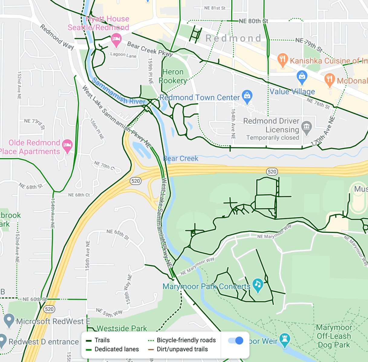 Bike paths along rivers, roads, highways, and parks
4. How to Watch Out For Google’s “Bike-Friendly Streets?”
Being cautious of Google’s “Bike-Friendly Streets” designation is essential when planning your bike route on Google Maps, as these routes may not always be as safe or pleasant as they appear; understanding the nuances of these streets can help ensure a safer ride. While the “Bike-Friendly Streets” notation can be useful, it’s important to verify the actual conditions before committing to the route.
4.1 Understanding “Bike-Friendly Streets”
Google Maps uses a dotted green line to indicate “Bike-Friendly Streets.” These roads are supposedly suitable for cycling, but the reality can vary widely.
4.1.1 Types of Roads Designated as “Bike-Friendly”
- Quiet Residential Streets: These are typically low-traffic streets in residential neighborhoods, ideal for cycling.
- Busy Car-Centric Streets: Sometimes, Google designates busy streets with no bike lanes as “Bike-Friendly” simply because they are part of an official bike route.
4.2 Potential Issues with “Bike-Friendly Streets”
The main issue is that the “Bike-Friendly” designation doesn’t always guarantee safety or comfort. Some of these streets may have:
- High Traffic Volume: Even without bike lanes, the traffic volume can make cycling unpleasant and dangerous.
- Poor Road Conditions: Potholes, cracks, and other road hazards can make cycling difficult.
- Lack of Shoulders: Without a shoulder, cyclists may have to ride in the travel lane, increasing the risk of accidents.
4.3 How to Verify “Bike-Friendly Streets”
To ensure a “Bike-Friendly Street” is truly suitable for cycling, take these steps:
- Use Street View: Check the road conditions, traffic volume, and the presence of bike lanes or shoulders.
- Read Reviews: Look for reviews or comments from other cyclists who have ridden the route.
- Consider Alternatives: If the “Bike-Friendly Street” doesn’t seem safe, look for alternative routes, such as parallel streets or bike paths.
4.4 Example of Verifying a “Bike-Friendly Street”
Suppose you’re planning a bike route in Sturgis, South Dakota, and Google Maps suggests a “Bike-Friendly Street” along Main Street. Using Street View, you can see that Main Street has heavy traffic and no bike lanes. Therefore, you might choose to find a quieter, safer route through a residential area.
4.5 Benefits of Being Cautious
By verifying the conditions of “Bike-Friendly Streets,” you can avoid potentially dangerous situations and ensure a more enjoyable and safer ride. This proactive approach aligns with the Motorcycle Safety Foundation’s (MSF) recommendations for pre-ride planning.
5. Finding Secret Bike-Friendly Streets
Finding secret bike-friendly streets that Google Maps doesn’t explicitly mark is a great way to discover quieter, safer, and more enjoyable cycling routes; these hidden gems can transform your riding experience. These streets are often residential roads with low traffic volume, making them perfect for cycling.
5.1 Why Some Streets Are Not Marked
Google Maps relies on various data sources to identify bike-friendly streets, but this data is not always complete or up-to-date. As a result, many excellent cycling routes go unmarked.
5.1.1 Lack of Official Surveys
Not all streets have been officially surveyed to determine their suitability for cycling. This means that many quiet, safe residential streets are not designated as bike-friendly.
5.1.2 Data Limitations
Google’s data may not reflect recent changes in traffic patterns or road conditions. A street that was once busy may now be quiet due to new traffic management measures.
5.2 How to Find Unmarked Bike-Friendly Streets
To find these hidden gems, use the following strategies:
- Look for Residential Areas: Focus on residential neighborhoods away from main roads. These areas often have quiet streets with low traffic volume.
- Use Satellite View: Identify parallel streets that run alongside busy roads. These streets may offer a quieter alternative.
- Explore Side Streets: Don’t be afraid to venture off the main roads and explore side streets. You may discover hidden gems that are perfect for cycling.
5.3 Verifying Unmarked Streets
Before committing to an unmarked street, verify its suitability for cycling by:
- Using Street View: Check the road conditions, traffic volume, and the presence of bike lanes or shoulders.
- Riding a Short Section: If possible, ride a short section of the street to assess its safety and comfort.
5.4 Example of Finding a Secret Bike-Friendly Street
Suppose you’re planning a bike route in Sturgis, South Dakota, and Google Maps directs you to a busy main road. By exploring the side streets, you may discover a quiet residential street that runs parallel to the main road, providing a safer and more enjoyable cycling experience. Local bikers often recommend these unmarked routes for their peaceful environment and scenic views.
5.5 Benefits of Exploring Unmarked Streets
By finding and using unmarked bike-friendly streets, you can create more enjoyable and safer cycling routes. This approach allows you to avoid busy roads and discover hidden gems in your local area.
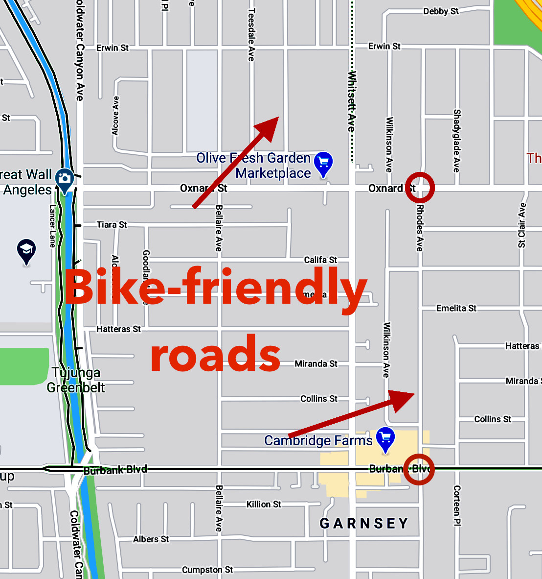 Bike-friendly roads on Google Maps
6. Loading Up Biking Directions to See the Hills
Loading up biking directions to see the hills on Google Maps is crucial for planning a comfortable and manageable bike route, allowing you to anticipate and prepare for elevation changes; this feature helps you avoid unexpected strenuous climbs. While Google Maps does have a terrain layer, using biking directions provides more specific information about the hills.
6.1 Why Check Elevation?
Understanding the elevation profile of your route helps you:
- Assess Difficulty: Determine if the route is suitable for your fitness level.
- Plan Your Effort: Pace yourself and conserve energy for challenging climbs.
- Avoid Unpleasant Surprises: Prevent unexpected steep hills that could ruin your ride.
6.2 How to See the Hills
To see the elevation profile of your bike route, follow these steps:
- Enter Your Start and End Points: Input your desired start and end locations in Google Maps.
- Select Biking Directions: Choose the biking option to generate a bike-specific route.
- View the Elevation Graph: Look for the elevation graph below the route options. This graph shows the elevation changes along your route.
6.3 Interpreting the Elevation Graph
The elevation graph displays the elevation changes along your route. Use it to identify:
- Steep Climbs: Look for sharp upward spikes in the graph.
- Gradual Climbs: Identify gentle upward slopes that may be less challenging.
- Descents: Spot downward slopes that indicate downhill sections.
6.4 Detouring Around Hills
If the elevation graph reveals steep climbs that you want to avoid, you can:
- Adjust Your Route: Drag the route line to explore alternative paths that may be flatter.
- Add Waypoints: Include additional stops to force Google Maps to recalculate the route and find a less hilly option.
6.5 Example of Using the Elevation Graph
Suppose you’re planning a bike ride in San Francisco. By loading up biking directions and viewing the elevation graph, you can see that Valencia Street has a noticeable uphill section. Knowing this, you can decide whether to tackle the hill or find an alternative route.
6.6 Benefits of Checking Elevation
By checking the elevation profile of your bike route, you can plan a more enjoyable and manageable ride. This proactive approach allows you to avoid challenging climbs and ensure that your route is suitable for your fitness level.
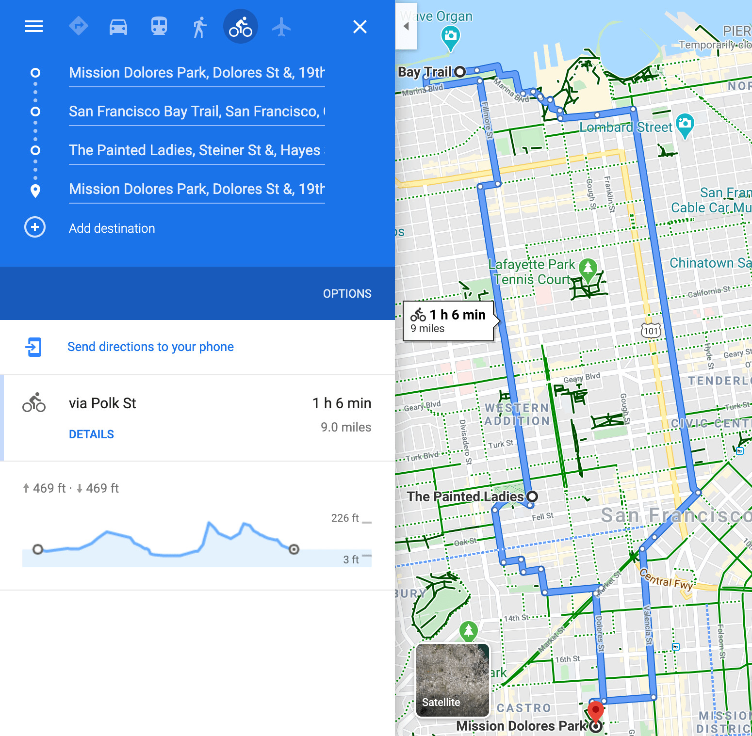 Hilly bike ride around San Francisco
7. Example: Exploring Fun Bike Routes
Exploring fun bike routes involves combining the previously discussed techniques to create enjoyable and safe cycling experiences; a practical example can illustrate how to use Google Maps effectively. This section provides a step-by-step guide to planning a bike route, using the city of Nashville, Tennessee, as an example.
7.1 Step 1: Activate the Bicycling Layer
First, activate the bicycling layer on Google Maps to identify potential bike routes in Nashville. Look for green lines indicating bike paths and lanes.
7.2 Step 2: Identify Potential Routes
Examine the map for interesting routes, such as:
- Paths Along Rivers: Nashville has several paths along its rivers that look promising.
- Parks and Green Spaces: Look for parks and green spaces that may have bike trails.
- Bike-Friendly Streets: Identify streets marked with dotted green lines.
7.3 Step 3: Use Street View
Use Street View to inspect the conditions of potential routes. Check for:
- Road Quality: Look for potholes, cracks, or other hazards.
- Traffic Volume: Assess the amount of traffic on bike-friendly streets.
- Bike Lanes: Verify the presence and condition of bike lanes.
7.4 Step 4: Check Elevation
Load up biking directions to see the elevation profile of your route. Identify any steep climbs that you may want to avoid.
7.5 Step 5: Explore Unmarked Streets
Look for unmarked residential streets that may offer a quieter alternative to busy roads.
7.6 Example Route in Nashville
Based on these steps, you might identify a route that follows the Richland Creek Greenway, a paved bike path that runs through a park. This route offers a scenic and safe alternative to the busier roads in Nashville.
7.7 Benefits of This Approach
By following these steps, you can plan a bike route that is both enjoyable and safe. This approach allows you to explore new areas with confidence, knowing that you have carefully considered the conditions of your route.
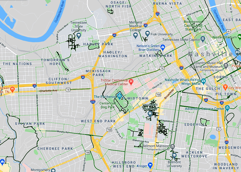 Close up of bike routes in Nashville, Tennessee
8. What Other Mapping Tools Can I Use To Plan A Bike Route?
Besides Google Maps, several other mapping tools can enhance your bike route planning, offering unique features and data; exploring these alternatives can provide a more comprehensive view and help you discover even better routes. These tools often provide more specialized features for cyclists, such as heatmaps, custom route drawing, and integration with fitness trackers.
8.1 Strava
Strava is a popular app among cyclists and runners, known for its social networking features and detailed activity tracking.
8.1.1 Heatmaps
Strava’s heatmap shows the most popular routes ridden by other cyclists, providing valuable insights into safe and enjoyable paths. According to Strava’s Year in Sport report, heatmaps help users discover new routes and avoid potentially dangerous areas.
8.1.2 Route Builder
Strava’s route builder allows you to create custom routes and sync them to your device for navigation.
8.2 Ride with GPS
Ride with GPS is a dedicated cycling app that offers advanced mapping and navigation features.
8.2.1 Custom Route Drawing
Ride with GPS allows you to draw custom routes and provides detailed elevation profiles.
8.2.2 Integration with GPS Devices
Ride with GPS integrates seamlessly with GPS devices, allowing you to navigate your routes with ease.
8.3 Komoot
Komoot is a route planning app that focuses on outdoor adventures, including cycling.
8.3.1 Highlight Feature
Komoot’s highlight feature recommends popular routes and points of interest, helping you discover hidden gems.
8.3.2 Offline Maps
Komoot offers offline maps, allowing you to navigate without an internet connection.
8.4 Local Bike Maps
Check with your local bike shop or cycling organization for printed bike maps. These maps often provide detailed information about bike paths, lanes, and other cycling resources.
8.5 Benefits of Using Multiple Tools
By using multiple mapping tools, you can gain a more comprehensive understanding of your route and discover the best options for your cycling adventure.
9. Locally Made Maps (Physical or Online)
Using locally made maps, whether physical or online, can greatly enhance your bike route planning by providing insights specific to the area; these maps often include details that aren’t available on mainstream platforms. These maps are created by local cycling enthusiasts who know the best routes and can offer valuable tips.
9.1 Advantages of Local Maps
Local maps offer several advantages:
- Detailed Information: They often include detailed information about road conditions, bike lanes, and points of interest that may not be available on Google Maps.
- Local Expertise: They are created by local cyclists who know the best routes and can offer valuable tips.
- Community Support: Purchasing a local map supports local businesses and cycling organizations.
9.2 Finding Physical Maps
You can find physical bike maps at:
- Local Bike Shops: Bike shops often carry maps of the local area.
- Cycling Organizations: Cycling organizations may offer maps to members.
- Visitor Centers: Visitor centers often have maps available for tourists.
9.3 Finding Online Maps
You can find online bike maps by:
- Searching Online: Use search engines to find bike maps for your area.
- Checking Local Government Websites: Local government websites often have maps of bike paths and lanes.
- Visiting Cycling Organization Websites: Cycling organizations often have maps available on their websites.
9.4 Example of Using a Local Map
Suppose you’re planning a bike route in Napa Valley. By using a local bike map, you can discover scenic routes through vineyards and wineries that are not marked on Google Maps. According to local cyclists, these routes offer a unique and enjoyable cycling experience.
9.5 Benefits of Using Local Maps
By using locally made maps, you can discover hidden gems and create more enjoyable and authentic cycling experiences. This approach allows you to connect with the local cycling community and support local businesses.
10. Global Heatmaps and Custom Route Drawing
Using global heatmaps and custom route drawing tools can significantly improve your bike route planning by showing you the most popular routes and allowing you to create personalized paths; these features offer a unique way to discover new routes and tailor them to your preferences. These tools are especially useful for finding safe and enjoyable routes in unfamiliar areas.
10.1 What Are Global Heatmaps?
Global heatmaps show the most popular routes ridden by other cyclists. These routes are highlighted on the map, making it easy to identify safe and enjoyable paths.
10.1.1 How Heatmaps Work
Heatmaps are generated by aggregating data from millions of rides. The more cyclists who ride a particular route, the brighter it appears on the heatmap.
10.1.2 Benefits of Using Heatmaps
- Discover Popular Routes: Heatmaps show you the most popular routes ridden by other cyclists.
- Identify Safe Paths: Popular routes are often safer and more enjoyable.
- Explore New Areas: Heatmaps help you discover new areas to ride.
10.2 Custom Route Drawing
Custom route drawing tools allow you to create personalized bike routes. These tools allow you to:
- Draw Routes Manually: Draw your route directly on the map.
- Add Waypoints: Include specific locations in your route.
- Customize Preferences: Specify your preferences, such as avoiding hills or busy roads.
10.3 Apps with Heatmaps and Route Drawing
Several apps offer heatmaps and route drawing tools, including:
- Strava: Strava is a popular app among cyclists and runners, known for its social networking features and detailed activity tracking.
- Ride with GPS: Ride with GPS is a dedicated cycling app that offers advanced mapping and navigation features.
- Komoot: Komoot is a route planning app that focuses on outdoor adventures, including cycling.
10.4 Example of Using Heatmaps and Route Drawing
Suppose you’re planning a bike route in a new city. By using a heatmap, you can identify the most popular routes ridden by other cyclists. You can then use a custom route drawing tool to create a personalized route that incorporates these popular paths.
10.5 Benefits of Using Heatmaps and Route Drawing
By using global heatmaps and custom route drawing tools, you can create bike routes that are both enjoyable and safe. These features allow you to discover new areas and tailor your routes to your preferences.
11. FAQ: Bike Route Planning on Google Maps
11.1 How Accurate Is the Bicycling Layer on Google Maps?
The bicycling layer on Google Maps is generally accurate but may not always reflect the most up-to-date conditions, verifying routes with Street View and local maps is recommended.
11.2 Can I Use Google Maps for Mountain Biking Routes?
Yes, but the bicycling layer may not show all off-road trails; combining Google Maps with specialized mountain biking apps like Trailforks is advisable.
11.3 How Do I Save a Bike Route on Google Maps?
You can save a bike route by creating a custom map and adding the route to it. Access “Your Places” in the menu, then “Maps,” and finally “Create Map.”
11.4 Does Google Maps Offer Turn-by-Turn Navigation for Bike Routes?
Yes, Google Maps provides turn-by-turn navigation for bike routes, available on both mobile and desktop versions.
11.5 Can I Report Errors in Bike Routes on Google Maps?
Yes, you can report errors by using the “Send Feedback” option in Google Maps, helping to improve the accuracy of the bicycling layer.
11.6 How Do I Find Bike Shops and Repair Stations on Google Maps?
Search for “bike shops” or “bike repair” in Google Maps to find nearby locations, and check reviews to ensure quality service.
11.7 Can I Use Google Maps Offline for Bike Routes?
Yes, download offline maps for the areas you plan to cycle through, ensuring you have access to navigation even without an internet connection.
11.8 How Do I Share a Bike Route with Friends on Google Maps?
Share a bike route by creating a link to the route and sending it via email or social media; ensure the route is saved on a custom map for easy sharing.
11.9 Does Google Maps Show Elevation Changes on Bike Routes?
Yes, Google Maps shows elevation changes in the biking directions, helping you plan for hills and challenging terrains.
11.10 How Can I Find Group Bike Rides Near Me Using Google Maps?
Search for local cycling clubs or events on Google Maps, and check their websites or social media for scheduled group rides. Usabikers.net also offers a community forum where you can find local biker groups and planned rides.
By using these tips and resources, you can plan safe, enjoyable, and memorable bike routes using Google Maps and other tools. Explore usabikers.net for more insights, community rides, and expert advice on all things biking.
Remember to bring your essentials and any gear you need to keep comfortable!
For more information, contact us:
Address: 801 Sturgis Main St, Sturgis, SD 57785, United States
Phone: +1 (605) 347-2000
Website: usabikers.net